صور المظاهر بواسطة MichaelJay. يتم التشغيل بواسطة Blogger.
أقسام المدونة :

الخميس، 7 يناير 2016

Deposition in Deserts

Deposition in Deserts

We've seen that erosion relentlessly eats away at bedrock and sediment in deserts. Where does the debris go? Below, we examine the various desert settings in which sediment accumulates.

Talus Aprons 

Production and transportation of debris and sediment in deserts.
Over time, joint-bounded blocks of rock break off ledges and cliffs on the sides of hills. Under the influence of gravity, the resulting debris tumbles downslope and accumulates as talus, a pile of debris at the base of a hill. Talus can survive for a long time in desert climates, so we typically see aprons of talus  fringing the bases of cliffs in deserts (figure above a).

Alluvial Fans 

Flash floods can carry sediment downstream in a steep-walled canyon. In some cases, the water contains so much sediment that it is best called a debris flow. When the turbulent water flows out into a plain at the mouth of a canyon, it spreads out over a broader surface and slows. As a consequence, sediment in the water settles out. The channel that emerges from the mountains tends to subdivide into a number of subchannels or distributaries that diverge outward. The network of distributaries spreads the sediment, or alluvium, out into a broad alluvial fan, a wedge- or apron-shaped pile of sediment (figure above b). Alluvial fans emerging from adjacent valleys may merge and overlap along the front of a mountain range, producing an elongate wedge of sediment called a bajada. Over long periods, the sediment of bajadas can fill in adjacent valleys to depths of several kilometres.

Playas and Salt Lakes 

Playas form where a shallow, salty lake dries up.
Water from a flash flood occasionally reaches the centre of an alluvium-filled basin. But if the supply of water is relatively small, the water quickly sinks into the permeable alluvium without accumulating as a standing body. During a particularly large storm or an unusually wet spring, however, a temporary lake may develop over the low part of a basin. During drier times, such desert lakes evaporate entirely, leaving behind a dry, flat, exposed lake bed known as a playa (figure above a, b). Over time, a smooth crust of clay and various salts (halite, gypsum, borax, and other minerals) accumulates on the surface of playas.
Where sufficient water flows into a desert basin, it creates a permanent lake. If the basin is an interior basin, with no outlet to allow water to flow out, the lake becomes very salty, because although its water escapes by evaporation in the desert sun, its salt cannot. The Great Salt Lake, in Utah, exemplifies this process. Even though the streams feeding the lake are fresh enough to drink, their water contains trace amounts of dissolved salt ions. Because the lake has no outlet, these ions have become concentrated in the lake over time, making it even saltier than the ocean.

Deposition from the Wind 

As mentioned earlier, wind carries two kinds of sediment loads a suspended load of dust-sized particles and a surface load of sand. Much of the dust is carried out of the desert and accumulates elsewhere. Sand, however, cannot travel far, and accumulates within the desert in piles called dunes, ranging in size from less than a meter to over 300 m high. In favourable locations, dunes accumulate to form vast “sand seas.”
Figures credited to Stephen Marshak.

الثلاثاء، 5 يناير 2016

Weathering and Erosional Processes in Deserts

Weathering and Erosional Processes in Deserts 

Without the protection of foliage to catch rainfall and slow the wind, and without roots to hold regolith in place, rain and wind can attack and erode the land surface of deserts and soil tends to be sparse. The result, as we have noted, is that hill slopes are typically bare, and plains can be covered with stony debris or drifting sand. 

Arid Weathering and Desert Soil Formation 

In the desert, as in temperate climates, physical weathering happens primarily when joints (natural fractures) split rock into pieces. Joint-bounded blocks eventually break free of bedrock and tumble down slopes, fragmenting into smaller pieces as they fall. In temperate climates, thick soil develops and covers bedrock. In deserts, however, bedrock commonly remains exposed, forming rugged, rocky escarpments.
Chemical weathering happens more slowly in deserts than in temperate or tropical climates, because less water is available to react with rock. Still, rain or dew provides enough moisture for some weathering to occur. This water seeps into rock and leaches (dissolves and carries away) calcite, quartz, and various salts. Leaching effectively rots the rock by transforming it into a poorly cemented aggregate. Over time, the rock will crumble and form a pile of unconsolidated sediment, susceptible to transport by water or wind. 
Although enough rain falls in deserts to leach chemicals out of sediment and rock, there is not enough rain to carry the chemicals away entirely. So they precipitate to form calcite and other minerals in regolith beneath the surface. The new minerals may bind clasts together to form a rock-like material called calcrete.

 Soil formation and chemical weathering in deserts.
Shiny desert varnish, a dark, rusty brown coating of iron oxide, manganese oxide, and clay, may cover the surface of rocks in deserts (figure above a). Desert varnish was once thought to form when water from rain or dew seeped into a rock, dissolved iron and magnesium ions, and carried the ions back to the surface of the rock by capillary action. More recent studies, however, suggest that desert varnish is not necessarily derived from the rock it coats. Instead, the iron and manganese in the varnish may come from dust that settles on the surface of the rock, for in the presence of moisture, micro-organisms (bacteria and archaea) can extract iron and manganese from the dust and transform it into oxide minerals. Such varnish won’t form in humid climates, because rain washes away the dust. 
Desert varnish takes a long time to form. In fact, the thickness of a desert varnish layer provides an approximate estimate of how long a rock has been exposed at the ground surface. In past centuries, Native Americans used desert-varnished rock as a medium for art: by chipping away the varnish to reveal the underlying lighter-coloured rock, they were able to create figures or symbols on a dark background. The resulting drawings are called petroglyphs. 
Because of the lack of plant cover in deserts, variations in bedrock and soil colour visually stand out. Slight variations in the concentration of iron, or in the degree of iron oxidation, in adjacent beds result in spectacular colour bands in rock layers and the thin soils derived from them. The Painted Desert of northern Arizona earned its name from the brilliant and varied hues of oxidized iron in the region’s shale bedrock (figure above b).

Water Erosion 

Evidence of erosion by running water in deserts.
Although rain rarely falls in deserts, when it does come, it can radically alter a landscape in a matter of minutes. Since deserts lack plant cover, rainfall, sheet wash, and stream flow are all extremely effective agents of erosion. It may seem surprising, but water generally causes more erosion than does the wind in most deserts (figure above a). 
Water erosion begins with the impacts of raindrops, which eject sediment from the ground into the air. On a hill, the ejected sediment lands downslope. The ground quickly becomes saturated with water during a heavy rain, so water starts flowing across the surface, carrying the loose sediment with it. Within minutes after a heavy downpour begins, dry stream channels fill with a turbulent mixture of water and sediment, which rushes downstream as a flash flood. When the rain stops, the water sinks into the stream bed’s gravel and disappears such streams are called intermittent, or ephemeral streams. Because of the relatively high viscosity of the water (owing to its load of suspended sediment) and the velocity and turbulence of the flow, flash floods in deserts cause intense erosion. Dry stream channels in desert regions of south-western North America are called dry washes, or arroyos, and in the Middle East and North Africa they are called wadis (figure above b). 

Wind Erosion 

In temperate and humid regions, plant cover protects the ground surface from the wind, but in deserts, the wind has direct access to the ground. Wind, just like flowing water, can carry sediment both as suspended load and as surface load. 

Sediment transport by wind in deserts.
Suspended load (fine-grained sediment such as dust and silt held in suspension) stays in the air for a long time and moves with it. The suspended sediment can be carried so high into the atmosphere (up to several kilometres above the Earth’s surface) and so far downwind (tens to thousands of kilometres) that it may move completely out of its source region. Particularly strong winds can generate a dramatic dust storm, or haboob, that can be 100 km long and 1.5 km high (figure above a). A dust storm, as it approaches, looks like a roiling, opaque wave. A particularly large one engulfed Phoenix, Arizona, in 2011, and shut down the airport. Dust storms are fairly common in the Sahara and Arabian Deserts, where they are known as haboobs.
Surface loads, or bed loads, start moving only in moderate to strong winds, for such winds can roll and bounce sand grains along the ground, a process called saltation. Saltation begins when turbulence caused by wind shearing along the ground surface lifts sand grains. The grains move downwind, following an asymmetric, arch-like trajectory. Eventually, they return to the ground, where they strike other sand grains, causing the new grains to bounce up and drift or roll downwind. The collisions between sand grains make the grains rounded and frosted. Saltating grains generally rise no more than 0.5 m, but where sand bounces on bedrock the grains may rise 2 m. 
The size of clasts that wind can carry depends on the wind velocity. Wind, therefore, does an effective job of sorting sediment, sending dust-sized particles skyward and sand-sized particles bouncing along the ground, while pebbles and larger grains remain behind. In some cases, wind carries away so much fine sediment that pebbles and cobbles become concentrated at the ground surface (figure above b, c). An accumulation of coarser sediment left behind when fine-grained sediment blows away is called a lag deposit. 

The progressive development of a ventifact.
Just as sandblasting cleans the grime off the surface of a building, windblown sand and dust grind away at surfaces in the desert. Over long periods of time, such wind abrasion creates smooth faces, or facets, on pebbles, cobbles, and boulders. If a rock rolls or tips relative to the prevailing wind direction after it has been faceted on one side, or if the wind shifts direction, a new facet with a different orientation forms, and the two facets join at a sharp edge. Rocks whose surface has been faceted by the wind are faceted rocks, or ventifacts (figure above). Wind abrasion also gradually polishes and bevels down irregularities on a desert pavement and polishes the surfaces of desert-varnished outcrops, giving them a reflective sheen. 
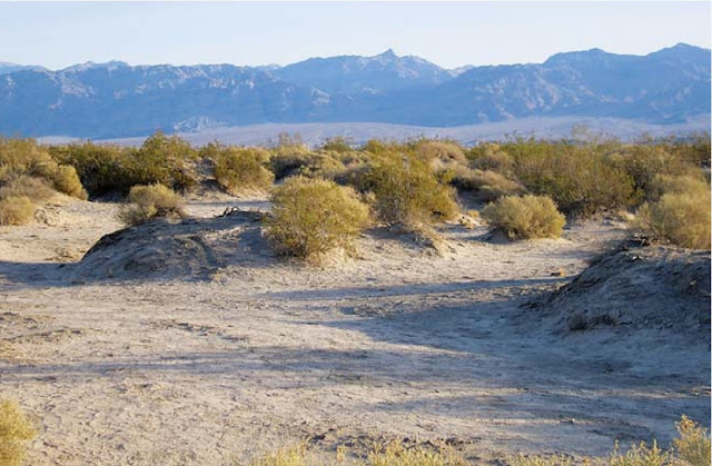
Wind erosion in Death valley has left bushes perched on mounds; roots keep soil from blowing away.
Over time, in regions where the substrate consists of soft sediment, wind picks up and removes so much sediment that the land surface becomes lower. The process of lowering the land surface by wind erosion is called deflation. Shrubs can stabilize a small patch of sediment with their roots, so after deflation a forlorn shrub with its residual pedestal of soil stands isolated above a lowered ground surface (figure above). In some places, the shape of the land surface twists the wind into a turbulent vortex that causes enough deflation to scour a deep, bowl-like depression called a blowout.
Figures credited to Stephen Marshak.

The Nature and Locations of Deserts

What Is a Desert? 

Formally defined, a desert is a region that is so arid (dry) that it supports vegetation on no more than 15% of its surface. In general, desert conditions exist where less than 25 cm of rain falls per year, on average. Because of the lack of water, deserts contain no permanent streams, except for those that bring water in from temperate regions elsewhere.
Note that the definition of a desert depends on a region’s aridity, not on its temperature. Geologists, therefore, distinguish between cold deserts, where temperatures generally stay below about 20C for the year, and hot deserts, where summer daytime temperatures exceed 35C. Cold deserts exist at high latitudes where the Sun’s rays strike the Earth obliquely and thus don’t provide much energy, at high elevations where the air is too thin to hold much heat, or in lands adjacent to cold oceans, where the cold water absorbs heat from the air above. Hot deserts develop at low latitudes where the Sun’s rays strike the desert at a high angle, at low elevations where dense air can hold a lot of heat, and in regions distant from the cooling effect of cold ocean currents. The hottest recorded temperatures on Earth occur in low-latitude, low-elevation  deserts 58C (136F) in Libya and 57C (133F) in Death Valley, California.

Types of Deserts 

Each desert on Earth has unique characteristics of landscape and vegetation that distinguish it from others. Geologists group deserts into five different classes, based on the environment in which the desert forms (figure below). 
Subtropical deserts form because the air that convectively flows downward in the subtropics warms and absorbs water as it sinks.
  • Subtropical deserts: Subtropical deserts (such as the Sahara, Arabian, Kalahari, and Australian) form because of the regional  pattern of air circulation in the atmosphere. At the equator, the air becomes warm and humid, for sunlight is intense and water rapidly evaporates from the ocean. The hot, moisture-laden air rises to great heights above the equator. As this air rises, it expands and cools, and can no longer hold so much moisture. Water condenses and falls in downpours that feed the lushness of the equatorial rain forest. The now-dry air high in the troposphere spreads laterally north or south. When this air reaches latitudes of 20 to 30 C, a region called the subtropics, it has become cold and dense enough to sink. Because the air is dry, no clouds form, and intense solar radiation strikes the Earth’s surface. The sinking, dry air becomes denser and heats up, soaking up any moisture present. In the regions swept by this hot air on its journey back to the equator, evaporation rates greatly exceed rainfall rates, so the land becomes parched. 
  • Deserts formed in rain shadows: As air flows over the sea toward a coastal mountain range, the air must rise (Fig. 17.3). As the air rises, it expands and cools. The water it contains condenses and falls as rain on the seaward flank of the mountains, nourishing a coastal rain forest. When the air finally reaches the inland side of the mountains, it has lost all its moisture and can no longer provide rain. As a consequence, a rain shadow forms, and the land beneath the rain shadow becomes a desert. A rain-shadow desert can be found east of the Cascade Mountains in the state of Washington.
 The formation of a rain-shadow desert. Moist air rises and drops rain on the coastal side of the range. By the time the air has crossed the mountains, it is dry. 
  • Coastal deserts formed along cold ocean currents: Cold ocean water cools the overlying air by absorbing heat, thereby decreasing the capacity of the air to hold moisture. For  example, the cold Humboldt Current, which carries water northward from Antarctica to the western coast of South America, cools the air that blows east, over the coast. The air is so dry when it reaches the coast that rain rarely falls on the coastal areas of Chile and Peru. As a result, this region hosts a desert landscape, including one of the driest deserts in the world, the Atacama (figure below a, b). Portions of this narrow desert received no rain at all between 1570 and 1971. 
  • Deserts formed in the interiors of continents: As air masses move across a continent, they lose moisture by dropping rain, even in the absence of a coastal mountain range. Thus, when an air mass reaches the interior of a broad continent, it has become so dry that the land beneath becomes arid. The largest present-day example of such a continental-interior desert, the Gobi, lies in central Asia. 
  • Deserts of the polar regions: So little precipitation falls in Earth’s polar regions (north of the Arctic Circle and south of the Antarctic Circle) that these areas are, in fact, arid. Polar regions are dry, in part, for the same reason that the subtropics are dry (the global pattern of air circulation means that the air flowing over these regions is dry), and in part, for the same reason that coastal areas along cold currents are dry (cold air holds little moisture).
 The formation of a coastal desert.
Different regions of the land surface have become deserts at different times in the Earth’s history, because plate movements change the latitude of landmasses, the position of landmasses relative to the coast, and the proximity of landmasses to a mountain range. Because of plate tectonics, some regions that were deserts in the past are temperate or tropical regions now, and vice versa.
Figures credited to Stephen Marshak.

الاثنين، 4 يناير 2016

Australian Coal Miner claims $3.3 Million for Workplace Injury


A Coal miner who claims he was permanently disabled in a workplace injury at a Moranbah site is suing BHP Billiton Mitsubishi Alliance for more than $3.3 million.

The man was injured in January 2013, when his arm was pinned while he unloaded cable reel at Moranbah's Broadmeadow Coal Mine.

Documents lodged in the Supreme Court at Rockhampton state the man was injured as he loosened the retaining bolts while unloading cable reel and "inadvertently placed his left arm into a pinch point position where it was pinned by an unexpected movement of the cable reel".

The man was pinned in that position for an hour.

The documents claim the man suffered "an extensive crush injury to the left upper arm with soft tissue and nerve damage from above the biceps to above the elbow joint" requiring multiple surgeries, including nerve grafting and tendon transfers. As a result of the grafting, he also suffered damage to nerves in both feet.

The man is suing the mining company for more than $3.3 million, including $180,000 of general damages for pain, suffering and loss of amenities of life.

The damages also include $1,787,000 for lost earning capacity into the future and $382,500 for future personal and domestic assistance.

A spokesperson for BHP Billiton Mitsubishi Alliance said the company took "the health and safety of all our employees very seriously and is focused on preventing injuries to its people".

"This is a concerning case which unfortunately involved a serious injury being sustained by one of BMA's employees almost three years ago. Since this incident occurred, BMA has sought to provide ongoing support to the injured employee ... for that entire period," they said. "Given this matter is currently subject to legal proceedings we cannot offer any further comment."

Source: Daily Mercury

الأحد، 3 يناير 2016

The World’s Largest Mining Dump Trucks


The dump trucks used in the mining sites are continue to grow larger, as most of the mining companies increasingly prefer big capacity dump trucks with greater functional efficiency. That’s why, the manufacturing companies try their utmost to bring out contemporary models of big-sized mining trucks to increase the productivity.

In this article Mining Engineers World presents you the details of the world’s top ten Mining dump trucks.

1.      Belaz 75710:
Belaz 75710, with payload of 450 mt, is the biggest dump truck in the world. It holds two Guinness World Records, for The Largest Truck Body and The Largest Two-axle dump Truck.

The Ultra-heavy dump truck was launched by BelAZ company in October 2013 under an order from Russian company Kuzbass. Sales of BelAZ 75710 trucks were started in 2014.

This massive Vehicle is 20.6m long, 8.17m high, and 9.75m wide. The truck has four-wheel drive and four-wheel hydraulic steering. It features two 16-cylinder turbocharged diesel engines with a power output of 4,600 HP. The 75710 uses electro-mechanical transmission powered by alternating current and has a top speed of 64 mph.

2. Caterpillar 797 F:
Caterpillar 797 F, the latest model of 797 class dump trucks manufactured and developed by caterpillar is the second largest truck in the world, with payload of 363 mt.

The truck is 14.8m long,6.52 m height and 9.75 m width. It features a Cat C175-20 four-stroke turbocharged diesel engine. The single block 20-cylinder engine utilizes a hydraulic torque converter transmission and offers gross power output of up to 4,000 HP and a maximum speed of 68 mph.

3. Unit Rig MT 6300: 
Initially, the truck was named as Terex MT 6300AC, introduced in 2008 by American manufacturer Terex. The MT 6300AC was rebranded as Bucyrus MT6300AC and became a part of Caterpillar's Unit Rig line after Caterpillar's acquisition of Bucyrus in 2011.

The body of the truck is 14.63 m in length, 7.92 m in height. The vehicle is equipped with a four-stroke diesel engine, with 20 cylinders and has a rated power output of the engine is 3,750 HP. The vehicle can move at a maximum speed of 64km/h

4. Liebherr T284

Liebherr T284 is an ultra-class haul truck designed and manufactured by Liebherr, with payload of 363 Tonnes. The trucks share the distinction of being the second biggest mining trucks with Caterpillar 797F and Unitrig MT 6300.

The overall length of the truck is 15.69 m, 8.29 m in height and 9.68 m in width. The vehicles are equipped with a 20-cylinder diesel engine with a gross power output of up to 3,750HP. The T 284 utilizes Liebherr’s insulated-gate biopolar transitor (IGBT) AC electric drive system and has a maximum speed of 64 Kmph.

5. Belaz 75604:
Belaz 75704 is the latest model of 7560 class of trucks designed by BelAZ, with payload of 360 mt. The truck was designed for carrying loosened rocks at deep open-pit mines under different climatic conditions.

The Belaz 75604 is 15.4 m in length, 7.47 m in height and 9.42 m in width. The dump truck uses electromechanical transmission with a four-cycle diesel engine, having 20 V-type cylinders. The engine's power output is 3,750HP. The top speed of Belaz 75604 is 64km/h.
BelAZ 75603 and 75602 are also similar Trucks with same payload capacity of 360mt.

6. Komatsu 960E – 2K / Komatsu 960E - 2

Komatsu 960E-2 and Komatsu 960E-2k are the two rigid dump trucks by Komatsu. Each truck has payload capacity of 327 mt. These are the latest trucks in 960E series of haul trucks from komatsu.

The truck is 7.67 m in height, 9.19 m in width and the overall length of 960E-2 and 960E-2K is 15.6 m and 15.34 m respectively. Both vehicles are powered by a four cycle diesel engine with 18 V-type cylinders. The power output of the engine is 3,500HP. Komatsu 960E-2 uses GE dual IGBT AC electric drive system, whereas the 960E-2K uses Komatsu IGBT AC electric drive system. The top speed of both the trucks is 64km/h.

7. Unit Rig MT 5500
Earlier Unit Rig MT 5500 known as Terex MT 5500 AC. It was designed and manufactured by Terex. Later Terex was acquired by Bucyrus and eventually in 2011 Bucyrus acquired by Caterpillar’s Unit Rig. It’s payload capacity is 326 mt.

The overall length is 14.87m, width is9.05m and height is 7.67m. The vehicle is powered by a four-stroke Diesel engine rated at 2,700HP with 16 cylinders. The vehicle uses AC electric drive system and travels at a maximum speed of 64km/h.

8. Terex 33-19 "Titan"

The terex 33-19 was an ultra-class, rigid frame, three axle, diesel/AC electric haul truck designed by the terex division of General Motars in 1973, with a payload capacity of 320 mt. 

Only one 33-19 was ever produced and it was the largest, highest capacity haul truck in the world for 25 years. After 13 years in service, the 33-19 was restored and is now preserved on static display as a tourist attraction in Sparwood, BC, Canada.

The overall length is 20.09 m, height is 6.88 m, and width is 7.57 m. The vehicle is powered by EMD 16-645E4 V-16 diesel engine with a gross generating capacity of 3,3000 HP. The truck runs at a top speed of 48 Km/h.

9. Caterpillar 795F AC:
Caterpillar 795F AC is the cat’s first AC electric drive truck, with payload capacity of 313 mt. The truck features modular design and offers two body options including the popular MSD (mine specific design) and the gateless coal body.

The truck is 15.14 m long, 7.04 m height and 8.97 m width. The vehicle is powered by Cat C175-16 diesel engine with a gross generating capacity of 3,400HP. The truck uses AC electric drive system solely designed and developed by Caterpillar, and runs at a top speed of 64km/h.


10. Hitachi EH5000AC-3:

Hitachi EH5000AC-3 is the Hitachi’s latest and largest rigid frame dump truck, with payload capacity of 296 mt. It was introduced at MINExpo International in Las vegas, Nevada in 2012.

The overall length of the truck is 15.49 m, height is 7.52 m and width is 9.6 m. The truck uses the low emission Cummins QSKTTA60-CE diesel engine with 16 cylinders. The rated power output of the four-cycle engine is 2,850HP. The vehicle uses Hitachi's IGBT AC electric drive system and runs at maximum speed of up to 56km/h.

If you have any quarries or suggestions regarding this article, mail us at miningengineersworld@gmail.com

السبت، 2 يناير 2016

Caves and Karst

Caves and Karst 

The Development of Caves 

In 1799, as legend has it, a hunter by the name of Houchins was tracking a bear through the woods of Kentucky when the bear suddenly disappeared on a hillslope. Baffled, Houchins plunged through the brambles trying to sight his prey. Suddenly he felt a draft of surprisingly cool air flowing down the slope from uphill. Now curious, Houchins climbed up the hill and found a dark portal into the hillslope beneath a ledge of rocks. Bear tracks were all around was the creature inside? He returned later with a lantern and cautiously stepped into the passageway. After walking a short distance, he found himself in a large, underground room. Houchins had discovered Mammoth Cave, an immense network of natural tunnels and subterranean chambers a walk through the entire network would extend for 630 km.
Most large cave networks develop in limestone bedrock because limestone dissolves relatively easily in corrosive groundwater. Generally, the corrosive component in groundwater is dilute carbonic acid (H2CO3), which forms when water absorbs carbon dioxide (CO2) from materials, such as soil, that it has passed through. When carbonic acid comes in contact with calcite (CaCO3) in limestone, it reacts to produce HCO31- and Ca2 ions, which then dissolve. 
In recent years, geologists have discovered that about 5% of limestone caves around the world form due to reactions with sulfuric-acid-bearing water Carlsbad Caverns in New Mexico serves as an example. Such caves form where limestone overlies strata containing oil, because microbes can convert the sulfur in the oil to hydrogen sulfide gas, which rises and reacts with oxygen to produce sulfuric acid, which in turn eats into limestone and reacts to produce gypsum and CO2 gas. 
Geologists debate about the depth at which limestone cave networks form. Some limestone dissolves above the water table, but it appears that most cave formation takes place in limestone that lies just below the water table, for in this interval the acidity of the groundwater remains high, the mixture of groundwater and newly added rainwater is not yet saturated with dissolved ions, and groundwater flow is fastest. The association between cave formation and the water table helps explain why openings in a cave network align along the same horizontal plane.

The Character of Cave Networks 

Development of karst, dripstone and flowstone.
As we have noted, caves in limestone usually occur as part of a network. Cave networks include rooms, or chambers, which are large, open spaces sometimes with cathedral-like ceilings, and tunnel-shaped or slot-shaped passages. Some chambers may host underground lakes, and some passageways may serve as conduits for underground streams. The shape of the cave network reflects variations in permeability and in the composition of the rock from which the caves formed. Larger open spaces developed where the limestone was most soluble and where groundwater flow was fastest. Thus, in a sequence of strata, caves develop preferentially in the more soluble limestone beds. Passages in cave networks typically follow pre-existing joints, for the joints provide secondary porosity along which groundwater can flow faster (figure above a). Because joints commonly occur in orthogonal systems (consisting of two sets of joints oriented at right angles to each other), passages may form a grid. 

Precipitation and the Formation  of Speleothems 

When the water table drops below the level of a cave, the cave becomes an open space filled with air. In places where downward percolating groundwater containing dissolved calcite emerges from the rock above the cave and drips from the ceiling, the surface of the cave gradually changes. As soon as this water re-enters the air, it evaporates a little and releases some of its dissolved carbon dioxide. As a result, calcium carbonate (limestone) precipitates out of the water and produces a type of travertine. The various intricately shaped formations that grow in caves by the accumulation of dripstone are called speleothems. 
Cave explorers (spelunkers) and geologists have developed a detailed nomenclature for different kinds of speleothems (figure above b). Where water drips from the ceiling of the cave, the precipitated limestone builds dripstone. Initially, calcite precipitates around the outside of the drip, forming a delicate, hollow tube called a soda straw. But eventually, the soda straw fills up, and water migrates down the margin of the cone to form a more massive, solid icicle-like cone called a stalactite. Where the drips hit the floor, the resulting precipitate builds an upward-pointing cone called a stalagmite. 
If the process of dripstone formation in a cave continues long enough, stalagmites merge with overlying stalactites to create travertine columns. In some cases, groundwater flows along the surface of a wall and precipitates to produce drape-like sheets of travertine called flowstone (figure above c). The travertine of caves tends to be translucent and, when lit from behind, glows with an eerie amber light.

The Formation of Karst Landscapes 

Features of Karst landscapes.
Limestone bedrock underlies most of the Kras Plateau in  Slovenia, along the east coast of the Adriatic Sea. The name kras, which means rocky ground, is apt because this region includes abundant rock exposures (figure above a). Geologists refer to regions such as the Kras Plateau, where surface landforms develop when limestone bedrock dissolves both at the surface and in underlying cave networks, as karst landscapes or karst terrains from the Germanized version of kras. 
Karst landscapes typically display a number of distinct landforms. Perhaps the most widespread are sinkholes, circular depressions that form either when the ground collapses into an underground cave below (as we discussed early in this chapter) or when surface bedrock dissolves in acidic water on the floor of a bog or pond. Not all of the caves or passageways beneath a karst landscape have collapsed, and this situation leads to unusual drainage patterns. Specifically, where surface streams intersect cracks (joints) or holes that link to caverns or passageways below, the water cascades downward into the subsurface and disappears (figure above b). Such disappearing streams may flow through passageways underground and re-emerge from a cave entrance downstream. In cases where the ground collapses over a long, joint-controlled passage, sinkholes may be elongate and canyon-like. Remnants of cave roofs remain as natural bridges. Ridges or walls between adjacent sinkholes tend to be steep-sided. Over time, the walls erode, leaving only jagged, isolated spires a karst landscape dominated by such spires is called tower karst. The surreal collection of pinnacles constituting the tower karst landscape in the Guilin region of China inspired generations of artists who portray them on scroll paintings (figure below).
Tower karst forms a spectacular landscape in southern China.
Karst landscapes form in a series of stages (figure below a–c).

The progressive formation of caves and a karst landscape.
  • The establishment of a water table in limestone: The story of a karst landscape begins after the formation of a thick interval of limestone in which the water table lies underground. 
  • The formation of a cave network: Once the water table has been established, dissolution begins and a cave network develops. 
  • A drop in the water table: If the water table later becomes lower, either because of a decrease in rainfall or because nearby rivers downcut and drain the region, newly formed caves dry out. Downward-percolating water emerges from the roofs of the caves; dripstone and flowstone precipitate. 
  • Roof collapse: If rocks fall off the roof of a cave for a long time, the roof eventually collapses. Such collapse creates sinkholes and troughs, leaving behind hills, ridges, and natural bridges.

Life in Caves 

Despite their lack of light, caves are not sterile, lifeless environments. Caves that are open to the air provide a refuge for bats as well as for various insects and spiders. Similarly, fish and crustaceans enter caves where streams flow in or out. Species living in caves have evolved some unusual characteristics. For example, cave fish lose their pigment and in some cases their eyes. Recently, explorers discovered caves in Mexico in which warm, mineral-rich groundwater currently flows. Colonies  of bacteria metabolize sulphur-containing minerals in this water and create thick mats of living ooze in the complete darkness of the cave. Long gobs of this bacteria slowly drip from the ceiling. Because of the mucus-like texture of these drips, they have come to be known as “snotites”.
Figures credited to Stephen Marshak.

الجمعة، 1 يناير 2016

Ethiopia Government engages private sector to scale up Mining Activity


The Ethiopian government, along with private sector partners, is taking steps to tap the country's vast underground resources.

“Ethiopia has considerable reserves of gold, potash, zinc, gemstones and tantalum,” geological survey consultant Yalew stated. “But they remain unstudied, unexplored and undeveloped.”

Ethiopian Minister of Mines, Petroleum and Natural Gas Tolossa Shagi stated that the government is stepping up efforts to support the mining industry.
“There is hope that Ethiopia will become a country in the short term whose extraction industry will contribute significantly to GDP,” the minister said in an interview.

The minister pointed out that revenue from mining had not met its goal, as defined by the government’s economic plan for 2014. Ethiopia had planned to secure mining revenue of $646 million during 2014/15 but only earned about half of that, $363 million, according to government statistics.

“Within a period of two years, Ethiopia will start natural gas production from its Kalub and Lala areas in the Somali regional state where 7.4 trillion cubic feet of natural gas is being developed for domestic use and for export via Djibouti,” the minister said. The government is financing the project, in a public-private partnership with the Chinese mining firm GCL; GCL will also build the pipeline to Djibouti.

“Indications of much larger deposits of natural gas have been found along the Great Rift Valley stretching as far south as Uganda, and exploration is underway in this area,” Shagi said.

Russian company GBP Global Resources, which was granted the concession in 2014, is currently exploring natural gas and oil reserves along the Ethiopian Rift valley area. Revenue will be shared between the company and the government if reserves are found.

“Currently eight exploration companies including from China and Russia are engaging in exploration and development of natural gas throughout the country,” he said.

The Midroc Group, a company owned by the Saudi businessman Al-Amoudi, is developing gold in Southern Ethiopia. The miner Alana Potash, acquired by Israel Chemicals in March 2015, is working on the massive deposits of potash in northeastern Ethiopia, Bekele said.

Ethiopia is developing its gem stone industry. According to the minister, small-scale traditional miners and middle men are earning about $25 million annually from gem stones that are to be found in abundance in many areas in the country.

“This can be increased tenfold if we transfer gem stone extraction to the mainstream mining sector,” Shagi said. “That is why we have recently put in place a Gemology Institute.”

According to Bekele, only 350,000 square kilometers (135,135 square miles) in total have been studied using seismic techniques for reserves. Ethiopia covers a total of 1,100,000 square kilometres (420,000 sq mi).

“Exploration should be intensified covering an expanded study area,” Bekele said; satellite images and surveys on the ground show Ethiopia holding immense resources under the surface.


Source: AA

Interested for our works and services?
Get more of our update !