صور المظاهر بواسطة MichaelJay. يتم التشغيل بواسطة Blogger.
أقسام المدونة :
‏إظهار الرسائل ذات التسميات Geology. إظهار كافة الرسائل

السبت، 4 نوفمبر 2017

Explore Fascinating Geology of Lofoten Islands, Norway

It is probably going to be boring what you are going to read, but if you are a geologist, please continue reading.
 What started as a simple fun trip with some friends to Lofoten Islands in northern Norway, just became a unique geological experience. This, because I think that, as a geologist, it is completely impossible to separate fun from my profession while traveling. It's just amazing to mix your profession with your favorite hobby. 
Trying to understand the rocks, the configuration of the landscapes and their phenomena, is simply priceless.
Reinebringen Mountain, Norway.
View to the town of Reine and Fjords.
Photo Credits: J. Sebastian Guiral
This time I got completely impressed with the beauty of the Fjords in Lofoten (help: what is a fjord? well basically, a fjord is a narrow and deep channel that allows the sea to enter to the land. They can be several kilometers long, so they are often confused with rivers or lakes, and can reach great depths, exceeding 1000 m. These geomorphological units are the product of sea flooding of valleys created by glacial activity).
Reinebringen mountain, Reine, Norway.
View to the town of Reine and Kirkefjord. U-shaped valleys and geomorphological features associated with intense tectonic activity. Glacial lake
Photo Credits: J. Sebastian Guiral
Hiking through the perfectly carved U-shaped valleys left me speechless (above mentioned glacial valleys). In each valley, it was possible to appreciate the sediments associated with the activity of the glacier, that is, the Moraines (frontal and lateral), till and reworked proglacial sediments.

Skelfjord, Lofoten, Norway.
Photo Credits: J. Sebastian Guiral


In addition, the typical vegetation of Tundra is impressive (help: what is Tundra? In simple words, it is a biome characterized by the lack of trees, the soils are mainly covered with mosses and lichens, characteristic of circumpolar latitudes. The subsoil is almost permanently frozen). This vegetation covered the base of the mountain chains and snowy hills, contrasting in a perfectly artistic way and offering a breathtaking view. 
Å, Moskenes, Norway.
Mosses on Precambrian gneisses and migmatites.
Photo Credits: J. Sebastian Guiral
Reine, Lofoten Norway.
View to Reinefjorden and snowy peaks
Photo Credits: J. Sebastian Guiral
Hamnøy, Lofoten Norway. Snowy Peaks.
Photo Credits: J. Sebastian Guiral
Haukland beach, Leknes, Lofoten, Norway

Snowy Peaks at Hamnøy, Lofoten Norway.
Photo Credits: J. Sebastian Guiral
What about lithologies? Well, broadly all those landscapes are conformed by a Precambrian basement represented by an Archean and Paleoproterozoic metamorphic complexes of ortho- and paragneisses, intruded by anorthosites and suites of charnokite-granites. This basement is in tectonic contact with amphibolites and paragneisses, which were intruded by tonalitic magmas at 470 Ma. Subsequently, at the top of the sequence, in a rather complex structural context, volcano-sedimentary sequences are found, ranging from the Permian to the Paleogene. These volcano-sedimentary sequences are part of the sea floor between Greenland and Norway. All these units are in well-marked tectonic contacts.

Utakleiv Beach, Leknes, Lofoten, Norway.
Paleoproterozoic amphibolites and gneisses.
Photo Credits: J. Sebastian Guiral
Utakleiv Beach, Leknes, Lofoten, Norway.
Paleoproterozoic amphibolites and gneisses
Photo Credits: J. Sebastian Guiral 

Paleoproterozoic amphibolites and gneisses at Haukland beach, Leknes, Lofoten, Norway
Photo Credits: J. Sebastian Guiral 

Finally, in addition to the geological stuff, the sunsets, perfect beaches, rainbows, snowstorms, the strong rain and a whole bunch of climatic phenomena associated with these high latitudes, make the Lofoten Islands one of the places. I have enjoyed a lot being a geologist. 

Reine, Lofoten Norway.
View of Reinefjorden and snowy peaks
Photo Credits: J. Sebastian Guiral 

 This is what I like about this profession, trying to understand a bit about such a complex, beautiful and huge planet.

If you are a geologist and feel the same as me while traveling, let me congratulate you.
You have a beautiful profession!
Sebas enjoying rain in Å, Moskenes, Norway.
Photo Credits: J. Sebastian Guiral 
  
Sebas exploring Paleoproterozoic amphibolites and gneisses at Utakleiv Beach, Leknes, Lofoten, Norway.
Photo Credits: J. Sebastian Guiral 
About authorJ. Sebastian Guiral is a Geological Engineer from the National University of Colombia. He is currently pursuing his master's program in Georesources Engineering at the Luleå University of Technology in Sweden. He also has  studied at the University of Liege in Belgium and at University of Lorraine in France. As a geologist, he has worked in important engineering and research projects in his country, which include geomechanics of underground excavations, geodynamics and geomorphology. Currently, his interests are focused on economic geology, exploration, mining and mineral processing techniques. 
You can contact with J. Sebastian Gujral at sebasguiralv@gmail.com or at Instagram: @sebasguiralv

We are grateful to J. Sebastian Gujral for sharing his knowledge and adventures with us. You can also contribute share your geological adventures with us. See details here.

الأحد، 10 سبتمبر 2017

Oil drilling Rig

What is Rig?

Owais Khattak at
KCA deutag 72 Location Makori East 6 MOL well
A drilling rig is a machine intend to drill hole in the Earth crust. Drilling rigs are massive structures which are used to drill hole for water, oil or natural gas. For water the rigs can be small, moved easily by one person which are termed as auger. But for oil or natural gas motives it can be very huge structures as you can see in the picture where it seems small but is tall about 46 meters. Drilling rigs can be mounted on trucks usually used for water wells or shallow wells. Small to medium-sized drilling rigs are mobile, such as those used in mineral exploration drilling, blast-hole, water wells and environmental investigations. Larger rigs are capable of drilling through thousands of metres of the Earth's crust, using large "mud pumps" to circulate drilling mud (slurry) through the drill bit and up the casing annulus, for cooling and removing the "cuttings" while a well is drilled. Hoists in the rig can lift hundreds of tons of pipe. Other equipment can force acid or sand into reservoirs to facilitate extraction of the oil or natural gas; and in remote locations there can be permanent living accommodation and catering for crews (which may be more than a hundred). Marine rigs may operate thousands of miles distant from the supply base with infrequent crew rotation or cycle.
As you see the rig in the picture where I stands with it, its a huge structure which is intended to drill deep into the Earth crust. This rig is 2000 horse power and able to drill deep because it can lift huge weight of the drill pipes. 

Rig components

Rig is basically made up of five components without which a rig is incomplete which will be discussed below and the components are
  1. Power
  2. Circulation system
  3. Hoisting system
  4. Rotation 
  5. Blowout preventer (BOP)

Power

A rig is always operated with some energy for the whole of the rig to operate which can be generated through some generators or by placing engines. The rig above was using five generators where three were operational for the rig every time because one cannot stop the rig it costs the operation and two were as backup engines. The power is necessary for a rig or its just a tall standing structure.

Circulation system

Circulation system in terms of rig is mud (slurry) which is made up of mud, water or oil which ever type of mud is required for the subsurface formation, and mixture of chemicals which includes gel, barite for increasing weight, caustic soda, defoamation etc. The mud is pumped from the mud tanks by mud pumps and travels through pipes into drill pipes which goes all the way down into the hole in pipes and gets out through holes in bit and returns to surface via annulus. Annulus is the inner diameter of the hole from which mud comes out to the surface bringing cuttings from the bore hole and creating mud cakes around the hole walls. The mud when comes out of the hole it goes to shakers where mud and well cuttings are separated. The mud also exerts hydrostatic pressure on the formation so that any fluid or gas from formation doesn't enters the bore hole.
Mud cake (1mm) produced in the lab with currently used mud which depicts the inner hole scenario.

Hoisting System

Hoisting system is done by the top drive system (TDS) which is held by strings and pulleys atop. The hoisting system is responsible for lifting the heavy weight of the drill pipes. If you cannot pull out or run in the drill pipes you cannot drill the hole. 

Rotation

Rotation refers to the rotation of drill pipes which in turn rotates the drill bit deep down the hole and cuts the formation. As the drill bit rotates and cuts the formation, if cuttings are not removed from the deep down hole the drill bit can stuck. If not stuck the drill bit will further be crushing the cutting and not the formation this is where the mud works comes in. It lifts up the cutting so that it can drill further and also cools down the bit as friction heats it up and deep the Earth itself is hot.

Blowout preventer (BOP)

BOP is the equipment installed at the surface where drill strings goes in it. The blowout preventer as the name itself is explanatory is used to stop the blowout. The BOP is 1, 2 or 3 stages preventer which is composed or either annulus ram and shear rams, annulus ram, shear rams or upper pipe ram or annulus ram, shear rams, upper pipe ram and lower pipe ram. The BOP is used when the formation pressure exceeds the hydrostatic pressure or else the fluid from the formation will enters the well which is termed as kick. When the kick reaches the surface it will blowout everything within and the rig itself so in order to stop that BOP is installed so that it can stop the pressure from coming out the hole.
BOP

الأربعاء، 21 يونيو 2017

Fault anatomy

Fault anatomy

Faults drawn on seismic or geologic sections are usually portrayed as single lines of even thickness. In detail, however, faults are rarely simple surfaces or zones of constant thickness. In fact, most faults are complex structures consisting of a number of structural elements that may be hard to predict. Because of the variations in expression along, as well as between, faults, it is not easy to come up with a simple and general description of a fault. In most cases it makes sense to distinguish between the central fault core or slip surface and the surrounding volume of brittlely deformed wallrock known as the fault damage zone, as illustrated in Figure 8.10.
Simplified anatomy of fault.
The fault core can vary from a simple slip surface with a less than millimeter-thick cataclastic zone through a zone of several slip surfaces to an intensely sheared zone up to several meters wide where only remnants of the primary rock structures are preserved. In crystalline rocks, the fault core can consist of practically non-cohesive fault gouge, where clay minerals have formed at the expense of feldspar and other primary minerals. In other cases, hard and flinty cataclasites constitute the fault core, particularly for faults formed in the lower part of the brittle upper crust. Various types of breccias, cohesive or non-cohesive, are also found in fault cores. In extreme cases, friction causes crystalline rocks to melt locally and temporarily, creating a glassy fault rock known as pseudotachylyte. The classification of fault rocks is shown in heading below.
In soft, sedimentary rocks, fault cores typically consist of non-cohesive smeared-out layers. In some cases, soft layers such as clay and silt may be smeared out to a continuous membrane which, if continuous in three dimensions, may greatly reduce the ability of fluids to cross the fault. In general, the thickness of the fault core shows a positive increase with fault throw, although variations are great even along a single fault within the same lithology. 
The damage zone is characterized by a density of brittle deformation structures that is higher than the background level. It envelops the fault core, which means that it is found in the tip zone as well as on each side of the core. Structures that are found in the damage zone include deformation bands, shear fractures, tensile fractures and stylolites, and Figure below shows an example of how such small-scale structures (deformation bands) only occur close to the fault core, in this case defining a footwall damage zone width of around 15 meters.
Damage zone in the footwall to a normal fault with 150–200 m throw. The footwall damage zone is characterized by a frequency diagram with data collected along the profile line. A fault lens is seen in the upper part of the fault. Entrada Sandstone near Moab, Utah.
The width of the damage zone can vary from layer to layer, but, as with the fault core, there is a positive correlation between fault displacement and damage zone thickness (Figure below a). Logarithmic diagrams such as shown in Figure below are widely used in fault analysis, and straight lines in such diagrams indicate a constant relation between the two plotted parameters. In particular, for data that plot along one of the straight lines in this figure, the ratio between fault displacement D and damage zone thickness DT is the same for any fault size, and the distance between adjacent lines in this figure represents one order of magnitude. Much of the data in Figure below a plot around or above the line D=DT, meaning that the fault displacement is close to or somewhat larger than the damage zone thickness, at least for faults with displacements up to 100 meters. We could use this diagram to estimate throw from damage zone width or vice versa, but the large spread of data (over two orders of magnitude) gives a highly significant uncertainty. 
A similar relationship exists between fault core thickness (CT) and fault displacement (Figure below b). This relationship is constrained by the straight lines D=1000CT and D-10CT, meaning that the fault core is statistically around 1/100 of the fault displacement for faults with displacements up to 100 meters.
(a) Damage zone thickness (DT) (one side of the fault) plotted against displacement (D) for faults in siliciclastic sedimentary rocks. (b) Similar plot for fault core thickness (CT). Note logarithmic axes. Data from several sources.
Layers are commonly deflected (folded) around faults, particularly in faulted sedimentary rocks. The classic term for this behavior is drag, which should be used as a purely descriptive or geometric term. The drag zone can be wider or narrower than the damage zone, and can be completely absent. The distinction between the damage zone and the drag zone is that drag is an expression of ductile fault-related strain, while the damage zone is by definition restricted to brittle deformation. They are both part of the total strain zone associated with faults. In general, soft rocks develop more drag than stiff rocks.

Fault rocks

When fault movements alter the original rock sufficiently it is turned into a brittle fault rock. There are several types of fault rocks, depending on lithology, confining pressure (depth), temperature, fluid pressure, kinematics etc. at the time of faulting. It is useful to distinguish between different types of fault rocks, and to separate them from mylonitic rocks formed in the plastic regime. Sibson (1977) suggested a classification based on his observation that brittle fault rocks are generally non-foliated, while mylonites are well foliated. He further made a distinction between cohesive and non-cohesive fault rocks. Further subclassification was done based on the relative amounts of large clasts and fine-grained matrix. Sibson’s classification is descriptive and works well if we also add that cataclastic fault rocks may show a foliation in some cases. Its relationship to microscopic deformation mechanism is also clear, since mylonites, which result from plastic deformation mechanisms, are clearly separated from cataclastic rocks in the lower part of the diagram. 

Fault breccia is an unconsolidated fault rock consisting of less than 30% matrix. If the matrix fragment ratio is higher, the rock is called a fault gouge. A fault gouge is thus a strongly ground down version of the original rock, but the term is sometimes also used for strongly reworked clay or shale in the core of faults in sedimentary sequences. These unconsolidated fault rocks form in the upper part of the brittle crust. They are conduits of fluid flow in non-porous rocks, but contribute to fault sealing in faulted porous rocks.
Pseudotachylyte consists of dark glass or microcrystalline, dense material. It forms by localized melting of the wall rock during frictional sliding. Pseudotachylyte can show injection veins into the sidewall, chilled margins, inclusions of the host rock and glass structures. It typically occurs as mm- to cm-wide zones that make sharp boundaries with the host rock. Pseudotachylytes form in the upper part of the crust, but can form at large crustal depths in dry parts of the lower crust. 

Crush breccias are characterised by their large fragments. They all have less than 10% matrix and are cohesive and hard rocks. The fragments are glued together by cement (typically quartz or calcite) and/or by microfragments of mineral that have been crushed during faulting.
Cataclasites are distinguished from crush breccias by their lower fragment–matrix ratio. The matrix consists of crushed and ground-down microfragments that form a cohesive and often flinty rock. It takes a certain temperature for the matrix to end up flinty, and most cataclasites are thought to form at 5km depth or more. 
Mylonites, which are not really fault rocks although loosely referred to as such by Sibson, are subdivided based on the amount of large, original grains and recrystallised matrix. Mylonites are well foliated and commonly also lineated and show abundant evidence of plastic deformation mechanisms rather than frictional sliding and grain crushing. They form at greater depths and temperatures than cataclasites and other fault rocks; above 300 C for quartz-rich rocks. The end-member of the mylonite series, blastomylonite, is a mylonite that has recrystallized after the deformation has ceased (postkinematic recrystallization). It therefore shows equant and strain-free grains of approximately equal size under the microscope, with the mylonitic foliation still preserved in hand samples.
Credits: Haakon Fossen (Structural Geology)

الخميس، 12 مايو 2016

Inside the Planet

Introduction


Seismologists, geologists who study seismic waves noticed in the early 20th century that P waves bended, or refracted, in their journey through Earth. Observations at stations far removed from the earthquake focus recorded waves that had traveled through the planet’s interior, as illustrated in part (1) of the figure.. Travel times of these waves indicated a refracted path, as shown in the figure, and wave speed is the distance divided by time (as determined by the amount of time elapsed since the start of the earthquake). Refraction was not too surprising because the increased pressure in Earth’s interior results in firmer structures and more resistance to oscillation, so the wave speed is greater and seismic waves refract. What surprised early seismologists was that beyond a certain point about 7,200 miles (11,600 km) from the focus, at an angular distance of 105 degrees S waves disappeared! 


In 1906 the British seismologist Richard D. Oldham (1858–1936) proposed that the disappearance of the shear waves was due to the “shadow” of a liquid core. Since S waves are shear, they cannot propagate through liquid, so the existence of a liquid center inside the planet would explain why seismometers fail to record shear waves on the other side of the planet from the focus, as shown in part (2) of the fi gure below. P waves, being compression waves, refract at the boundary between rock and liquid, creating a smaller “shadow.” Th e rocky interior beneath the crust is called the mantle, and in 1914 the German seismologist Beno Gutenberg (1889–1960) used the seismic wave results to calculate that the mantlecore boundary is located at a depth of about 1,800 miles (2,900 km) below the surface. However, in 1936 the Danish seismologist Inge Lehmann (1888– 1993) analyzed seismic wave data and discovered an additional refractory step of P waves. Her analysis suggested the existence of another boundary, which she placed at a depth of about 3,200 miles (5,150 km). This boundary is between an outer core and an inner core. 

The use of seismic waves to image Earth’s interior is similar to the use of ultrasound waves to image the body’s interior or sound waves in sonar to image the seafloor. Unlike ultrasound and sonar techniques, though, seismologists usually do not generate seismic waves these are natural occurrences beyond the control of researchers. Yet the waves reveal a lot of information about otherwise inaccessible places. Seismic waves are also plentiful; about 1 million or so earthquakes occur each year in the world, and although most of these are fortunately minor they are detectable with sensitive instruments. 

By studying the nature and speed of seismic waves, geologists have learned much about the Earth’s interior. Earth consists of the following several layers:
  • crust, composed of rocks having relatively low density, extending from the continental surface to an average depth of about 22 miles (35 km) and from the ocean floor an average of about four miles (6.4 km) down to a boundary known as the Mohorovicic discontinuity (Moho for short), named after the Croatian scientist Andrija Mohorovičić (1857–1936); 
  • mantle, extending from the crust to about 1,800 miles (2,900 km) below the surface, and divided into an upper and a lower section; 
  • outer core, which is liquid and extends from the mantle border to a depth of about 3,200 miles (5,150 km); 
  • inner core, which is solid, with a radius of about 750 miles (1,220 km).

The mantle gets its name from Wiechert, who thought of it as a coat that covered the core (mantle derives from the German word, mantel, for “shell” or “coat”). About 67 percent of Earth’s mass is contained in this large region. The mantle is mostly solid, although as discussed below there is some degree of fluidity in spots; it consists of minerals such as olivine and another silicate called perovskite (MgSiO3). Silicon and aluminium are less abundant in the mantle compared to the crust, but magnesium is much more plentiful. 

Wiechert assumed from the studies of Earth’s density that the core must be dense. A greater density for the core also makes sense because the large portion of the heavier elements would have sunk to the interior as the hot, molten planet formed long ago. Iron and nickel possess relatively high densities and are commonly found in certain meteorites, indicating their abundance throughout the solar system. These metals are likely constituents of the core. The absence of shear wave propagation indicates the outer core is liquid, but studies of other seismic waves indicates a density slightly less than that expected if the outer core contained only melted iron and nickel. Instead, the outer core is about 90 percent iron and nickel, and most of this is iron about 85 percent of the outer core is made of this element. The remaining 10 percent consists of lighter elements such as sulphur and oxygen.

The inner core forms a boundary with the outer core, reflecting some of the waves and transmitting the rest. Shear waves cannot pass through the outer core, but as compression waves cross the boundary between the inner and outer core, some of these disturbances create shear waves. The shear waves travel through the inner core and get converted back into compression waves as they proceed from the inner to the outer core. Seismologists can detect the paths of these waves, and the propagation of shear waves in the inner core implies it cannot be liquid. Density studies suggest the inner core is mostly solid iron, mixed with a small percentage of nickel. 
Researchers continue to study seismic waves and similar data to learn more of the details on the structure and composition inside Earth. In 2005 John W. Hernlund and Paul J. Tackley of the University of California, Los Angeles, and Christine Thomas of the University of Liverpool in the Britain found data suggesting the presence of a thin layer around the mantle-core boundary. This layer, previously unknown and not yet widely studied, might help scientists to understand and identify further properties of the mantle. The researchers published their report “A Doubling of the Post-Perovskite Phase Boundary and Structure of the Earth’s Lowermost Mantle” in a 2005 issue of Nature.
Although researchers can study the finer structure of Earth’s hidden interior with sensitive seismometers, a large amount of information could also be gained by burrowing inside and taking a look. There are limitations on how far down people can drill, even with the hardest bits (the tip of the drill), but researchers are sharpening their drill bits in the effort to reach greater depths.

الأحد، 1 مايو 2016

Petroleum system


Petroleum System


In order to understand the petroleum generation and extraction petroleum system should be known
Petroleum system starts with the deposition to storage from where the production is obtained.
Petroleum system journey starts with the deposition of organic matter.

Deposition of organic matter

The deposition of organic matter starts when organism starts to die and deposits deep down the ocean floor and the above deposition of clay (finer grains). The clay particles are about 1/256 mm size and is called shale. Organic matter deposited on the ocean floor cannot be oxidized due to the depth factor so they can produce hydrocarbon. Hydrocarbon generation needs the cooking of organic matter at high temperature and pressure and it is obtained when it goes into overburden of deposition by clay particles and greater depths. 

Source rock

In the petroleum system the source rock are the shale (clay that goes under high pressure and temperature which cooks the organic matter). Sometimes limestone can also be the source rock with 1% of organic matter contains. So theses rocks undergo cooking where the temperature and pressure determines what type of fuel will be generated. Despite of temperature and pressure another factor in producing hydrocarbon is the time span required to generate fuel. The time is a critical factor as if the organic matter is cooked for less time it will not generate hydrocarbon and when it is greater than the oil produce will be converted into gas.

Reservoir rock

Reservoir as indicated by the name reserves of hydrocarbon. the hydrocarbon cannot be obtained from the source rock because of the higher pores but are lesser to none interconnection. For the extraction the pores should be interconnected so that it can travel when are extracted. But if there is no reservoir and obtaining fuel from source rock it must be fractured for permeability generation. Reservoir rock are mostly sandstone which have higher porosity and permeability but in some cases limestone also serves as reservoir rock. Limestone all by self is not a good reservoir due to fine particles present which give less permeability but as limestone is calcium carbonate so it can be dissolved in water which are the Karst topography. Only then can limestone have permeability required for hydrocarbon to be obtained.

Migration

Primary migration

Migration itself is cleared so the primary migration occurs when hydrocarbon moves from source rock to the reservoir rocks. Primary migration occurs when the source rock is fractured due to tectonic forces (plate movements) or by the overburden squeezing the source rock. As HC (hydrocarbon) have low density they moves upward. 

Secondary migration

Secondary migration is the HC movement within the reservoir rocks. The HC will moves upward in the reservoir rocks.

Seal rock

Trap or seal rocks are those that are present above reservoir rocks as HC movement will always be upward. Seal rock are those that have low to none permeability so that HC cannot escape but are trapped within the reservoir rocks. Shale can be seal rock also as they have porosity but do not have permeability factor so HC will be trapped. Types of traps include stratigraphic and structural.
Stratigraphic traps example is shale as a seal rock and structural traps are fold or faults. 

Time period

The last thing in the petroleum system is time as have said it above already, time is required for HC generation which is always critical. No more time and no less time while cooking of the organic matter or it will not produce the fuel.

Online geology degree and courses

Online geology degree and courses


Online geology degree and courses are offered at multiple forums. Geology is study of the rocks, minerals, and the forces that shape the earth, like water, wind and earthquakes. Learn about the levels of geology degrees online you can pursue partly or fully online, common courses and career options in the field. Schools offering Environmental Science degrees can also be found in these popular choices.
A geology degree is widely valued by employers when looking for employment as a geoscientist, hydrogeologist, or an environmental attorney. Geology majors also go on to work as a sedimentologist, a geophysicist, and many other important careers that help our environment. The schools we list on our site are accredited degree programs in geology and related fields at the associate and bachelor’s degree levels.

Definition of Geology

Geology is a science that studies the Earth and the materials that it’s made of. It looks at the rocks that the Earth is composed of, the structure of the earth’s materials, and the processes acting upon those materials that cause the Earth to evolve. Through the study of geology we can understand the history of the Earth. Geologists decipher evidence for plate tectonics, the evolutionary history of life, and the past climates the Earth has been through. Geology also includes the study of organisms that have inhabited the planet, and how they’ve changed over time.
Currently we use geology for mineral and hydrocarbon exploration, evaluating water resources, predicting natural hazards, finding remedies for environmental problems, providing insights into past climate change, and geotechnical engineering. Through geology degrees people can study geology, become a geologist, and use their knowledge to improve our Earth.

A Geology Education - An Overview

If you’re interested in studying online geology degree, there are a few different degree options open to you in both undergrad and graduate education. The following are a few options:
  • Bachelor of Arts in Geology: The BA in geology degree is intended for students who plan to pursue teacher certification, natural resource management, scientific or technical writing, and other fields that combine a strong liberal arts background with science training. BA classes may include earth materials, minerals, igneous and metamorphic rocks, oceanography, principles of astronomy, deformation of the Earth, sedimentary processes, earth surface processes, and field methods.
  • Bachelor of Science in Geology: The BS in geology degree differs from the BA in that it has a strong mathematical component. It’s typically designed for students planning to pursue graduate study in geology, or work as a professional geologist. Courses may include: History of the Earth, Earth materials, deformation of the Earth, sedimentary processes, Earth surface processes, field methods, chemistry, physics, physics in electricity and magnetism, and calculus classes.
  • Master of Science in Geology: This is a graduate degree in geology. Master programs are advanced geology degrees with a focus on geology classes. They typically come in both thesis and non-thesis options. Those who want to get a master’s in geology degree must have an undergraduate degree in geology or a closely related science field. Sometimes they’ll let applicants without a bachelor’s degree in geology to take pre-requisite classes before beginning a master’s program. Pre-requisite classes include: physical geology, mineralogy, paleobiology, petrography, geologic field methods, stratigraphy, igneous/metamorphic petrogenesis, structural geology, sedimentary petrogenesis, and introduction to geophysics.
  • Doctorate in Geology: A PhD is the highest level of degree a person can get in geology. These programs are designed to develop creative scholarship and to prepare the student for a professional career in the geological sciences. Typically a person chooses a specialization or focus such as geochemistry, geology, geophysics, planetary geology, minerals, or more. Students can be admitted into PhD programs with either a bachelor’s or master’s degree in geology. Depending on the previous degree earned, a PhD may take one to two years of study.
In all geology degree levels, the goal is for students to master basic concepts and vocabulary in geology. Through these programs you’ll learn the following materials:
  • Plate tectonics
  • Origin and classification of rocks and minerals
  • Geological time scale and how this relates to major events in the history of Earth and its life
  • Geophysical properties of the Earth and crustal deformation
  • Processes that shape the surface of the Earth
  • Environmental hazards and issues
You’ll also be expected to:
  • Develop skills in observing and recording geologic features and processes
  • Develop competency in the interpretation of earth science data, including both qualitative and quantitative analyses
  • Achieve competence in: locating and interpreting scientific literature,
  • Giving oral presentations,
  • Using computers at a level consistent with current professional practice
  • Be able to express earth science concepts in writing

What Geology online Degrees Are Available?

You can pursue a Bachelor of Arts, Bachelor of Science, Master of Science in geology and Ph.D. in geology. People who earn a B.S. in Geology usually pursue advanced degrees. However, in a Master of Science program in geology, your classmates may have a B.S. in Geology or an undergraduate degree in a related field like engineering or physics. The online geology degree or online geoscience degree can be obtain in B.S.
While some schools offer some geology courses online, entire undergraduate degree programs online are extremely rare. Many science lab courses can't be completed online, and fieldwork requires in-person attendance. However, it is possible to earn a Bachelor of Arts, Bachelor of Science, or Master of Science in Geology entirely online with taking online geology courses.


Online Degrees                Bachelor's and Master's degrees available online
                                                                                                                                                                   

Online                              Computer, software, completing assignments by due date, degree 

Requirements                   completion within 8 years

                                                                                                                                                                   
Common Courses            Soils, hydrology, plate tectonics, chemistry, physics


Career Options                Geochemist, mineralogist, government geologist, geology teacher 
                                                                                                                                                                   

How Do I Complete My Degree Online?


In an online degree geology program, classes start and end at the same calendar time as the on-campus courses. You do not have to be logged in to the class at a specific time, and instead may view the lectures at your convenience. However, during the course, you may be given assignments that have specific due dates. All of your assignments must be completed by the last day of class.
You may have up to eight years to complete your degree. Students attending part-time take 3-4 years to complete their geology master's degree online. If you choose to attend full-time, you may be able to complete your geology online degree faster. You will need access to specific software, usually available for purchase through the school.

What Topics Will I Study?

In a bachelor's online degree in geology program, you learn how certain rocks and minerals are formed and how to classify them. You study the forces that shape Earth's surface, such as weather and plate tectonics, the movement of the Earth's crust. You may also take classes about soil, hydrology or palaeontology. You can also expect to take classes in math, computers, chemistry and physics.
You will likely have to complete a field course, in which you may spend an entire semester or a summer in the field, practising your skills on a real-world geology project. Some schools offer field courses on-campus, while others offer them only at off-campus sites.
Master's degree students concentrate coursework and thesis projects on a particular area of interest, like earthquake prediction or environmental geology. Ph.D. students take their interest to the next level by completing a dissertation that contributes original research to their chosen area of geology.

What Kinds of Careers Will Be Open to Me?

While you will be qualified for entry-level employment with only a geology bachelor's degree, many graduates choose to pursue either an advanced geology degree or a professional degree for a career that joins the two interests. For example, you could pursue your law degree and work in environmental law.
Geology graduates can find employment as an oceanographer, geochemist or mineralogist, doing direct science research. You could work for the U.S. Geological Survey, or advise state and local agencies on infrastructure planning and policy. Some graduates with advanced degrees also pursue teaching careers.

What universities offer online degrees?

Online geology courses?


الجمعة، 29 أبريل 2016

Giant Sinkhole Eats Highway in Oregon

Giant Sinkhole Eats Highway in Oregon

This gigantic sinkhole opened after a heavy rainstorm along the Oregon coast.
The startling chasm, which started out less than a foot across in mid-December, suddenly turned into a monster 80 feet in diameter on Jan. 28, after an inch and a half of rain caused a culvert to fail and triggered a landslide nearby. The hole has closed down the stretch of U.S. 101 that runs through the unincorporated town of Harbor, just south of the city of Brookings, according to news reports.
Officials reportedly have estimated that it will take at least a week to repair the hole, which started in the parking lot of the Fireside Diner, and then grew to devour a big hunk of the highway. To further exacerbate the situation, a second, smaller sinkhole opened up in the middle of the road itself.
spectacular drone video of the damage, shot by local resident Kyle Rice, already has attracted nearly 200,000 views on YouTube. The hole also has attracted coverage from BBC News and Russia’s RT.com, where some readers used it as fodder for anti-American retorts and conspiracy theories. “Research shows US is one big sinkhole,” one wrote, while another suggested that it may have been caused by “hundreds of underground tunnels throughout America.”


The actual explanation is a bit less bizarre. According to the U.S. Geological Survey, sinkholes happen frequently where the rocks below the land surface are porous enough to be dissolved by groundwater circulating through them. 
Though USGS identifies Florida, Texas, Alabama, Missouri, Kentucky, Tennessee, and Pennsylvania as the states where the most sinkhole damage occurs, Oregon also has a history of really big sinkholes. The big kahuna was a 50-foot-deep, 100-foot-long hole that appeared on Interstate 5 near Roseburg in November 1996, causing a pair of big rigs to plunge into it.

الجمعة، 22 أبريل 2016

The Pleistocene Ice Age

The Pleistocene Ice Age 

The Pleistocene Glaciers 

Today, most of the land surface in New York City lies hidden beneath concrete and steel, but in Central Park it’s still possible to see land in a seminatural state. If you stroll through the park, you’ll find that the top surfaces of outcrops are smooth and polished, and in places have been grooved and scratched. Here and there, glacial erratics rest on the bedrock. You are seeing evidence that an ice sheet once scraped along this now-urban ground. Geologists estimate that the ice sheet that overrode the New York City area may have been 250 m thick, enough to bury a 75-story building. 
The fact that glaciated landscapes still decorate the surface of the Earth means that the last ice age occurred fairly recently during Earth’s history. Otherwise, the landscape features would have been either eroded away or buried. The ice age responsible for the glaciated landscapes of North America, Europe, and Asia happened mostly during the Pleistocene Epoch, which began about 2.6 Ma, so as we’ve noted earlier, it is commonly known as the Pleistocene Ice Age. 

Pleistocene ice sheets of the northern hemisphere.

Based on studying patterns of glacial striations and of the sources of erratics, geologists have developed an approximate idea of where the great Pleistocene ice sheets originated, and the directions in which the ice sheets flowed. In North America, major ice sheets appear to have initiated in at least three locations (figure above). The Labrador ice sheet formed over north-eastern Canada, the Keewatin ice sheet originated in north-western Canada, and the Baffin ice sheet formed over 
Baffin Bay. These sheets, together with one or more smaller ones, merged to form the giant Laurentide ice sheet that covered all of Canada east of the Rocky Mountains, and spread southward over the northern portion of the United States. The Cordilleran ice sheet, which originated in the mountains of western Canada, spread westward to the Pacific coast and eastward until it merged with the Laurentide ice sheet. Other ice sheets formed in Greenland, Scandinavia, northern Russia, and Siberia.
In addition to continental ice sheets, sea ice in the  northern hemisphere expanded to cover all of the Arctic Ocean and parts of the North Atlantic during the Pleistocene. Sea ice surrounded Iceland and approached Scotland and also fringed most of western Canada and southeastern Alaska. 

Life and Climate in the Pleistocene World 

Climate belts during the Pleistocene.
During the Pleistocene Ice Age, all climatic belts shifted southward (figure above a, b). Geologists can document this shift by examining fossil pollen, which can survive for thousands of years if preserved in the sediment of bogs. 
Fossils also tell us that numerous species of now-extinct large mammals inhabited the Pleistocene world (figure above c). Giant mammoths and mastodons, relatives of the elephant, along with woolly rhinos, musk oxen, reindeer, giant ground sloths, bison, lions, saber-toothed cats, giant cave bears, and hyenas wandered forests and tundra in North America. Early human-like species were already foraging in the woods by the beginning of the Pleistocene Epoch, and by the end modern Homo sapiens lived on every continent except Antarctica, and had discovered fire and invented tools. 

Timing of the Pleistocene Ice Age 

Louis Agassiz assumed that only one ice age had affected the planet. But close examination of the stratigraphy of glacial deposits on land revealed that paleosols (ancient soil preserved in the stratigraphic record), as well as beds containing fossils of warmerweather animals and plants, lay between distinct layers of glacial sediment. This observation suggested that between episodes of glacial deposition, glaciers receded and temperate climates prevailed. In the second half of the 20th century, when modern methods for dating geological materials became available, the difference in ages between the different layers of glacial sediment could be confirmed. Clearly, glaciers advanced and then retreated more than once during the Pleistocene. Times during which the glaciers grew and covered substantial areas of the continents are called glacial periods, or glaciations, and times between glacial periods are called interglacial periods, or interglacials. 

Pleistocene glacial deposits in the north-central United States. Curving moraines reflect the shape of glacial lobes.
Using the on-land sedimentary record, geologists recognized five Pleistocene glaciations in Europe and, traditionally, four in the mid-western United States (Wisconsinan, Illinoian, Kansan, and Nebraskan, named after the southernmost states in which their till was deposited; figure above). Since the mid-1980s, geologists no longer recognize Nebraskan and Kansan; they are lumped together as “pre-Illinoian.” 
The chronology of glaciations was turned on its head in the 1960s, when geologists began to study submarine sediment. They found that some layers contained glacially transported grains, while others did not. Similarly, they found that at a given location, some layers contained fossils of cold-water plankton and other fossils of warm-water plankton. Researchers found that in sediment of the last 2.6 million years, there is evidence for 20 to 30 glaciations during the Pleistocene Epoch. The traditionally recognized glaciations of Europe and the United States might represent only the largest of these. 

The timing of glaciations. Ice ages have occurred at several times in the geologic past.
Geologists refined their conclusions about the frequency of Pleistocene glaciations by examining the isotopic composition of fossil shells. Shells of many plankton species consist of calcite (CaCO3). The oxygen in the shells includes two isotopes, a heavier one (18O) and a lighter one (16O). The ratio of these isotopes tells us about the water temperature in which the plankton grew; this is because as water gets colder, plankton incorporate a higher proportion of 18O into their shells. The isotope record confirms that 20 to 30 of these events occurred during the last 2.6 million years (figure above a). 

Older Ice Ages during Earth History 

So far, we’ve focused on the Pleistocene Ice Age because of its importance in developing Earth’s present landscape. Was this the only ice age during Earth history, or do ice ages happen frequently? To answer such questions, geologists study the stratigraphic record and search for ancient glacial deposits that have hardened into rock. These deposits, called tillites, consist of larger clasts distributed throughout a matrix of sandstone and mudstone. In many cases, tillites are deposited on glacially polished surfaces.
By using the stratigraphic principles, geologists have determined that tillites were deposited during the Late Paleozoic; these are the deposits Alfred Wegener studied when he argued in favour of continental drift (figure above b). Tillites were also deposited between 850 and 630 Ma (at the end of the Proterozoic Eon), about 2.4 to  2.1 Ga (near the beginning of the Proterozoic), and perhaps about 2.9 Ga (in the Archean Eon). Strata deposited at other times in Earth history do not contain tillites. Thus, it appears that glacial advances and retreats have not occurred steadily throughout Earth history, but rather are restricted to specific time intervals, or ice ages, of which there were four or five: Pleistocene, Permian, late Proterozoic, early Proterozoic, and perhaps Archean. 
Of particular note, some tillites of the late Proterozoic event were deposited at equatorial latitudes, suggesting that, for at least a short time, the continents worldwide were largely glaciated, and the sea may have been covered worldwide by ice. Geologists refer to the ice-encrusted planet as snowball Earth.
Credits: Stephen Marshak (Essentials of Geology)

السبت، 26 مارس 2016

Vanishing Rivers

Vanishing Rivers 

As Homo sapiens evolved from hunter-gatherers into farmers, areas along rivers became attractive places to settle. Rivers serve as avenues for transportation and are sources of food, irrigation water, drinking water, power, recreation, and (unfortunately) waste disposal. Further, their floodplains provide particularly fertile soil for fields, replenished annually by seasonal floods. Considering the multitudinous resources that rivers provide, it’s no coincidence that ancient cultures developed in river valleys and on floodplains. Nevertheless, over time, humans have increasingly tended to abuse or overuse the Earth’s rivers. Here we note four pressing environmental issues pertaining to rivers.
  • Pollution: The capacity of some rivers to carry pollutants has long been exceeded, transforming them into deadly cesspools. Pollutants include raw sewage and storm drainage from urban areas, spilled oil, toxic chemicals from industrial sites, floating garbage, excess fertilizer, and animal waste. Some pollutants directly poison aquatic life, some feed algae blooms that strip water of its oxygen, and some settle out to be buried along with sediments. 
  • Dam Construction: In 1950, there were about 5,000 large (over 15 m high) dams worldwide, but today there are over 38,000. Damming rivers has both positive and negative results. Reservoirs provide irrigation water and hydroelectric power, and they trap some floodwaters and create popular recreation areas. But in some locations their construction destroys “wild rivers” (the whitewater streams of hilly and mountainous areas) and alters the ecosystem of a drainage network by forming barriers to migrating fish, by decreasing the nutrient supply to organisms downstream, by removing the source of sediment for the delta, and by eliminating seasonal floods that replenish nutrients in the landscape.
The Central Arizona Project canal shunts water from the Colorado River to Phoenix.
  • Overuse of Water: Because of growing populations, our thirst for river water continues to increase, but the supply of water does not. The use of water has grown especially in response to the “green revolution” of the 1960s, during which huge new tracts of land came under irrigation. Today, 65% of the water taken out of rivers is used for agriculture, 25% for industry, and 9% for drinking.  As a result, in some places human activity consumes the entire volume of a river’s water, so that the channel contains little more than a saline trickle, if that, at its mouth. For example, except during unusually wet years, the Colorado River’s channel contains almost no water where it crosses the Mexican border, for huge pipes and canals carry the water instead to Phoenix and Los Angeles (figure above). 
  • Effects of Urbanization and Agriculture on Streams: When it rains in a naturally vegetated region, or in an agricultural region, much of the water that falls from the sky either soaks into the ground or gets absorbed by plants. Some of the soil moisture or groundwater eventually seeps into a nearby stream, but the remainder flows elsewhere underground. As a result, the amount of water that reaches nearby streams after a storm is less than the total amount of precipitation, and a significant lag occurs between the time when the water falls and when the stream’s discharge increases. Urbanization changes both the volume of water reaching the stream and the length of the time lag, because when developers transform fields and forests into parking lots, roads, and buildings, a layer of impermeable concrete and asphalt prevents rainfall from infiltrating, and the amount of living biomass is smaller. Storm sewers and streets divert water directly to streams, so not only does the volume of water entering the streams increase, but also the rate at which the volume changes increases. 
  • Although we tend to think of farmland as “vegetated land,” it actually has less plant cover than does natural grassland or forest. That’s because the land surface between the crop rows remains bare during the growing season, and after harvest, entire fields become a broad expanse of exposed soil. Sheetwash flowing across the unprotected land surface erodes and carries with it significant volumes of sediment. Thus, a river’s sediment load increases significantly when farms replace  forests nearby.
Credits: Stephen Marshak (Essentials of Geology)

الثلاثاء، 22 مارس 2016

The Geologic Column

The Geologic Column

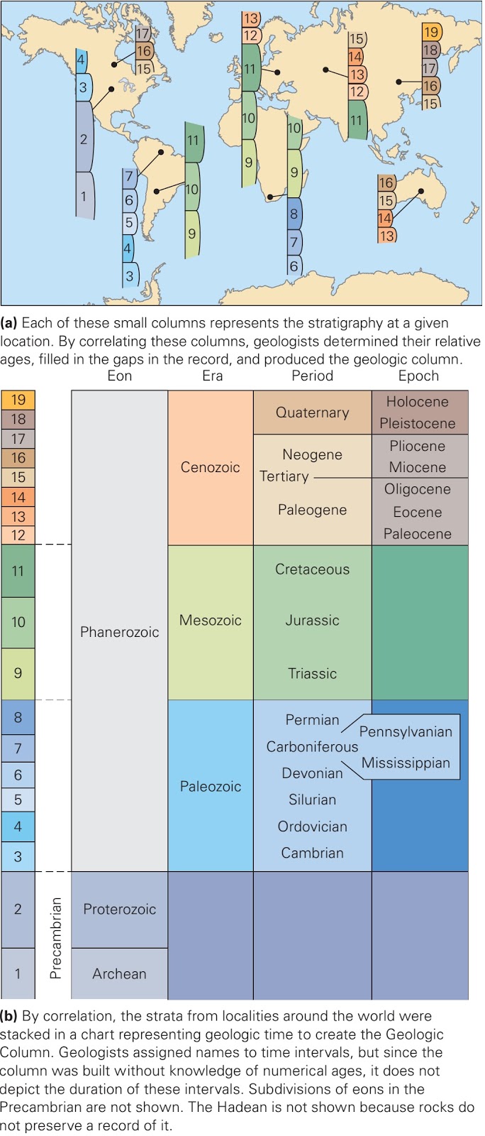
Global correlation of strata led to the development of the geologic column.
As stated earlier, no one locality on Earth provides a complete record of our planet’s history, because stratigraphic columns can contain unconformities. But by correlating rocks from locality to locality at millions of places around the world, geologists have pieced together a composite stratigraphic column, called the geologic column, that represents the entirety of Earth history (figure above a, b). The column is divided into segments, each of which represents a specific interval of time. The largest subdivisions break Earth history into the Hadean, Archean, Proterozoic, and Phanerozoic Eons. (The first three together constitute the Precambrian.) The suffix zoic means life, so Phanerozoic means visible life, and Proterozoic means first life. (It wasn’t until after the eons had been named that geologists determined that the earliest life, cells of Bacteria and Archaea, appeared in the Archean Eon.) The Phanerozoic Eon is subdivided into eras. In order from oldest to youngest, they are the Paleozoic (ancient life), Mesozoic (middle life), and Cenozoic (recent life) Eras. We further divide each era into periods and each period into epochs.
Where do the names of the periods come from? They refer either to localities where a fairly complete stratigraphic column representing that time interval was first identified (for example, rocks representing the Devonian Period crop out near Devon, England) or to a characteristic of the time (rocks from the Carboniferous Period contain a lot of coal). The terminology was not set up in a planned fashion that would make it easy to learn. Instead, it grew haphazardly in the years between 1760 and 1845, as geologists began to refine their understanding of geologic history and fossil succession. Also, because the divisions were defined before numerical ages could be determined, they are all of different durations.

Life evolution in the context of the geologic column. The Earth formed at the beginning of the Hadean Eon.
The succession of fossils preserved in strata of the geologic column defines the course of life’s evolution throughout Earth history (figure above). Simple bacteria and archaea appeared during the Archean Eon, but complex shell-less invertebrates did not evolve until the late Proterozoic. The appearance of invertebrates with shells defines the Precambrian-Cambrian boundary. At this time, there was a sudden diversification in life, with many new types of organisms appearing over a relatively short  interval this event is called the Cambrian explosion. 
Progressively more complex organisms populated the Earth during the Paleozoic. For example, the first fish appeared in Ordovician seas, land plants started to spread over the continents during the Silurian (prior to the Silurian, the land surface was unvegetated), and amphibians appeared during the Devonian. Though reptiles appeared during the Pennsylvanian Period, the first dinosaurs did not stomp across the land until the Triassic. Dinosaurs continued to inhabit the Earth until their sudden extinction at the end of the Cretaceous Period. For this reason, geologists refer to the Mesozoic Era as the Age of Dinosaurs. Small mammals appeared during the Triassic Period, but the diversification (development of many different species) of mammals to fill a wide range of ecological niches did not happen until the beginning of the Cenozoic Era, so geologists call the Cenozoic the Age of Mammals. Birds also appeared during the Mesozoic (specifically, at the beginning of the Cretaceous Period), but underwent great diversification in the Cenozoic Era. 

Correlation of strata among the national parks of Arizona and Utah.
To conclude our discussion of the geologic column, let’s see how it comes into play when correlating strata across a region. We return to the Colorado Plateau of Arizona and Utah, in the southwestern United States (figure above a, b). Because of the lack of vegetation in this region, you can easily see bedrock exposures on the walls of cliffs and canyons; some of these exposures are so beautiful that they have become national parks. Using correlation techniques, geologists have determined that the oldest sedimentary rocks of the region crop out near the base of the Grand Canyon, whereas the youngest form the cliffs of Cedar Breaks and Bryce Canyon. Walking through these parks is thus like walking through Earth’s history each rock layer gives an indication of the climate and topography of the region at a time in the past. For example, when the Precambrian metamorphic and igneous rocks exposed in the inner gorge of the Grand Canyon first formed, the region was a high mountain range, perhaps as dramatic as the Himalayas today. When the fossiliferous beds of the Kaibab Limestone at the rim of the canyon first developed, the region was a Bahama-like carbonate reef and platform, bathed in a warm, shallow sea. And when the rocks making up the towering red cliffs of sandstone in Zion Canyon were deposited, the region was a Sahara-like desert, blanketed with huge sand dunes.
Credits: Stephen Marshak (Essentials of Geology)

Interested for our works and services?
Get more of our update !