صور المظاهر بواسطة MichaelJay. يتم التشغيل بواسطة Blogger.
أقسام المدونة :
‏إظهار الرسائل ذات التسميات glacier. إظهار كافة الرسائل

الأربعاء، 30 مارس 2016

Consequences of Continental Glaciation

Consequences of Continental Glaciation

Ice Loading and Glacial Rebound 

The concept of subsidence and rebound, due to continental glaciation and deglaciation. (Not to scale.)
When a large ice sheet (more than 50 km in diameter) grows on a continent, its weight causes the surface of the lithosphere to sink. In other words, ice loading causes glacial subsidence. Lithosphere, the relatively rigid outer shell of the Earth, can sink because the underlying asthenosphere is soft enough to flow slowly out of the way (figure above). Because of ice loading, much of Antarctica and Greenland now lie below sea level, so if their ice were instantly to melt away, these continents would be flooded by a shallow sea.
What happens when continental ice sheets do melt away? Gradually, the surface of the underlying continent rises back up, by a process called glacial rebound, and the asthenosphere flows back underneath to fill the space. This process doesn't take place instantly, the asthenosphere flows so slowly (at rates of a few millimetres per year) that it takes thousands of years for ice-depressed continents to rebound. Thus, glacial rebound is still taking place in some regions that were covered by ice during the Pleistocene Ice Age.

Sea-Level Changes: The Glacial Reservoir 

The link between sea level and global glaciation: glaciers store water so when glaciers grow, sea level falls, and when glaciers melt, sea level rises.
More of the Earth’s surface and near-surface freshwater resides in glacial ice than in any other reservoir. During the Pleistocene Ice Age, glaciers covered almost three times as much land area so they held significantly more water than they do today. In effect, water from the ocean reservoir transferred to the glacial reservoir and remained trapped on land. As a consequence, sea level dropped by as much as 100 m, and extensive areas of continental shelves became exposed as the coastline migrated seaward (figure above a–c). People and animals populated the exposed coastal plains. The drop in sea level also created land bridges across the Bering Strait between North America and northeastern Asia, providing convenient migration routes for prehistoric humans. 

Ice Dams, Drainage Reversals, and Lakes 

When ice freezes over a sewer opening in a street, neither meltwater nor rain can enter the drain, and the street floods. Ice sheets play a similar role in glaciated regions. The ice may block the course of a river, leading to the formation of a lake. In addition, the weight of a glacier changes the tilt of the land surface and therefore the gradients of streams, and glacial sediment may fill pre-existing valleys. In sum, continental glaciation modifies or destroys pre-existing drainage networks. While the glacier exists, streams find different routes and carve out new valleys; by the time the glacier melts away, these new streams have become so well established that old river courses may remain abandoned. 

Meltwater Floods 

Subsidence of the land surface at the toe of a glacier locally led to the growth of large ice-margin lakes. Inevitably, the ice dams that held back these lakes melted and broke. In a matter of hours to days, the contents of the lakes drained, creating immense flood-waters that stripped the land of soil and left behind huge ripple marks. For example, glacial Lake Missoula, in Montana, filled when glaciers advanced and blocked the outlet of a large valley. When the glaciers retreated, the ice dam broke, releasing immense torrents the Great Missoula Flood that scoured eastern Washington, creating a barren, soil-free landscape called the channelled scablands.

Ice-age lakes in North America.
The largest known ice-margin lake covered portions of Manitoba and Ontario, in south-central Canada, and North Dakota and Minnesota in the United States (figure above a). This body of water, Glacial Lake Agassiz, existed between 11,700 and 9,000 years ago, a time during which the most recent phase of the last ice age came to a close and the continental glacier retreated north. At its largest, the lake covered over 250,000 square km (100,000 square miles), an area greater than that of all the present Great Lakes combined. The sudden release of water from Lake Agassiz may have led to a sea-level rise of 1 to 3 m during a single year. 

Pluvial Features 

During the Pleistocene Ice Age, the climate in regions to the south of continental glaciers was wetter than it is today. Fed by enhanced rainfall, lakes accumulated in low-lying land at a great distance from the ice front. Many such pluvial lakes (from the Latin pluvia, rain) flooded interior basins of the Basin and Range Province in Utah and Nevada (figure above b). The largest pluvial lake, Lake Bonneville, covered almost a third of western Utah. When this lake suddenly drained after a natural dam holding it back broke, it left a bathtub ring of shoreline rimming the mountains near Salt Lake City. Today’s Great Salt Lake is but a small remnant of Lake Bonneville. 

Periglacial Environments 

Periglacial regions are not ice covered but do include substantial areas of permafrost.
In polar latitudes today, and in regions adjacent to the fronts of continental glaciers during the last ice age, the mean annual temperature stays low enough (below 5C) that soil moisture and groundwater freeze and, except in the upper few meters, stay solid all year. Such permanently frozen ground is called  permafrost. Regimes with widespread permafrost that do not have a cover of snow or ice are called periglacial environments (the Greek peri means around, or encircling; periglacial environments appear around the edges of glacial environments; figure above a). 
The upper few meters of permafrost may melt during the summer months, only to refreeze again when winter comes. As a consequence of the freeze-thaw process, the ground of some permafrost areas splits into pentagonal or hexagonal shapes, creating a landscape called patterned ground (figure above b). 
Permafrost presents a unique challenge to people who live in polar regions or who work to extract resources from these regions. For example, heat from a building may warm and melt underlying permafrost, creating a mire into which the building settles. For this reason, buildings in permafrost regions must be placed on stilts, so that cold air can circulate beneath them to keep the ground frozen. 
Credits: Stephen Marshak (Essentials of Geology)

الأحد، 27 مارس 2016

Deposition Associated with Glaciation

Deposition Associated with Glaciation 

The Glacial Conveyor 

The glacial conveyor and the formation of lateral and medial moraines on glaciers.
Glaciers can carry sediment of any size and, like a conveyor belt, transport it in the direction of flow (that is, toward the toe;  figure above a). The sediment load either falls onto the surface of the glacier from bordering cliffs or gets plucked and lifted from the substrate and incorporated into the moving ice. Geologists refer to a pile of debris carried by or left by glaciers as a moraine. Sediment dropped on the glacier’s surface moves with the ice and becomes a stripe of debris. Stripes formed along the side edges of the glacier are lateral moraines. When a glacier melts, lateral moraines lie stranded along the side of the glacially carved valley, like bathtub rings. Where two valley glaciers merge, the debris constituting two lateral moraines merges to become a medial moraine, running as a stripe down the interior of the composite glacier (figure above b). Trunk glaciers created by the merging of many tributary glaciers contain several medial moraines. Sediment transported to a glacier’s toe by the glacial conveyor accumulates in a pile at the toe and builds up to form an end moraine.

Types of Glacial Sedimentary Deposits 

Several different types of sediment can be deposited in  glacial environments; all of these types together constitute  glacial drift. The term dates from pre-Agassiz studies of glacial deposits, when geologists thought that the sediment had “drifted” into place during an immense flood. Specifically,  glacial drift includes the following: 

Sedimentation processes and products associated with glaciation. Glacial sediment is distinctive.
  • Till: Sediment transported by ice and deposited beneath, at the side, or at the toe of a glacier is called glacial till. Glacial till is unsorted because the solid ice of glaciers can carry clasts of all sizes (figure above a). 
  • Erratics: Glacial erratics (figure above b) are cobbles and boulders that have been dropped by a glacier. Some lie within or on till piles, and others rest on glacially polished surfaces. 
  • Glacial marine: Where a sediment-laden glacier flows into the sea, icebergs calve off the toe and raft clasts out to sea. As the icebergs melt, they drop the clasts. Sediment consisting of ice-rafted clasts mixed with marine sediment makes up glacial marine. 
  • Glacial outwash: Till deposited by a glacier at its toe may be picked up and transported by meltwater streams that sort the sediment. The clasts are deposited by a braided stream network to form a broad area of gravel and sandbars called an outwash plain. This sediment is known as glacial outwash (figure above c). 
  • Loess: When the warmer air above ice-free land beyond the toe of a glacier rises, the cold, denser air from above the glacier rushes in to take its place. A strong wind, called katabatic wind, therefore blows at the margin of a glacier. This wind picks up fine clay and silt and transports it away from the glacier’s toe. Where the winds die down, the sediment settles and forms a thick layer. This sediment, called loess, sticks together because of the electrical charges on clay flakes. Thus, steep escarpments can develop by erosion of loess deposits (figure above d).
  • Glacial lake-bed sediment: Streams transport fine clasts, including rock flour, away from the glacial front. This sediment eventually settles in meltwater lakes, forming a layer of glacial lake-bed sediment that commonly contains varves. A varve is a pair of thin layers deposited during a single year. One layer consists of silt brought in during spring floods and the other of clay deposited in winter when the lake’s surface freezes over and the water is still (figure above e).

Depositional Landforms of Glacial Environments 

The formation of depositional landforms associated with continental glaciers.
Picture a group of hunters, dressed in reindeer skin, gazing southward from the crest of an ice cliff at the toe of a continental glacier in what is now southern Canada. It’s about 12,000 years ago, and the glacier has been receding for at least a millennium. The hunters would have been able to see a variety of landscape features, some formed by glacial erosion and some by deposition, due to moving ice and meltwater. We've already described erosional features, so now let’s focus on the depositional features of the landscape (figure above a, b).
From their vantage point, the hunters would probably have seen a few curving, hummocky ridges of sediment in the region between the glacier’s toe and the horizon. Each of these ridges is an end moraine, formed when the position of the glacier’s toe remained in the same location for a while. Ice keeps flowing to the toe, and like a giant conveyor belt, transports sediment to the toe. As the ice melts, this sediment accumulates to form a pile of till, and this pile comprises the end moraine. Geologists refer to the end moraine at the farthest limit of glaciation as the terminal moraine. In the northeastern United States, a large terminal moraine built up during the Pleistocene Ice Age this ridge of sediment now underlies Long Island, New York, and Cape Cod, Massachusetts (figure above c). When a glacier starts receding, it may stall several times the end moraines that form when a glacier stalls while receding are known as recessional moraines. The hummocky layer of till between end moraines is known as lodgment till or ground moraine. Since this till was deposited by moving ice, clasts within it may be aligned and scratched. 

Knob-and-kettle topography and drumlins characterize some areas that were once glaciated.
The hummocky surface of a moraine reflects both variations in the amount of sediment supplied by the ice and the development of kettle holes. A kettle hole is a roughly circular depression made when a block of ice that calved off the toe of a glacier became buried by till. When the block eventually melts, it leaves behind a depression (figure above a, b). Geologists refer to a land surface spotted with many kettle holes separated by rounded hills or ridges of sediment as “knob-and-kettle topography” (figure above c). 
In some locations, glacial ice flow molds underlying till into an elongate hill known as a drumlin (from the Gaelic word for small hill or ridge). Drumlins commonly occur in swarms, and tend to be about 50 m high. Their long axis trends parallel to the flow direction of the glacier. Notably, drumlins taper in the direction of flow a drumlin’s upstream end is steeper than its downstream end (figure above d, e).

Eskers are snake-like ridges of sand and gravel that form when sediment fills meltwater tunnels at the base of a glacier.
As we've noted, not all of the sediment or “drift” associated with glacial landscapes was deposited directly by ice, for meltwater also carries and deposits sediment. Water transported sediment, in contrast to till, tends to be sorted and stratified. Sediment deposited in meltwater tunnels beneath a glacier itself may remain as a sinuous ridge, known as an esker, when the glacier melts away (figure above a, b). Braided meltwater streams that flow beyond the end of a glacier deposit layers of sand and gravel that underlie glacial outwash plains. Meltwater may collect in a lake adjacent to the glacier’s toe, to form an ice-margin lake. Additional lakes and swamps may form in low areas on the ground moraine. Sediments deposited in eskers and glacial outwash plains serve as important sources of sand and gravel for construction, and the fine sediment of former glacial lake beds evolves into fertile soil for agriculture.
Credits: Stephen Marshak (Essentials of Geology)

Carving and Carrying by Ice

Carving and Carrying by Ice

Glacial Erosion and Its Products 

Products of glacial erosion. Ice is a very aggressive agent of erosion.
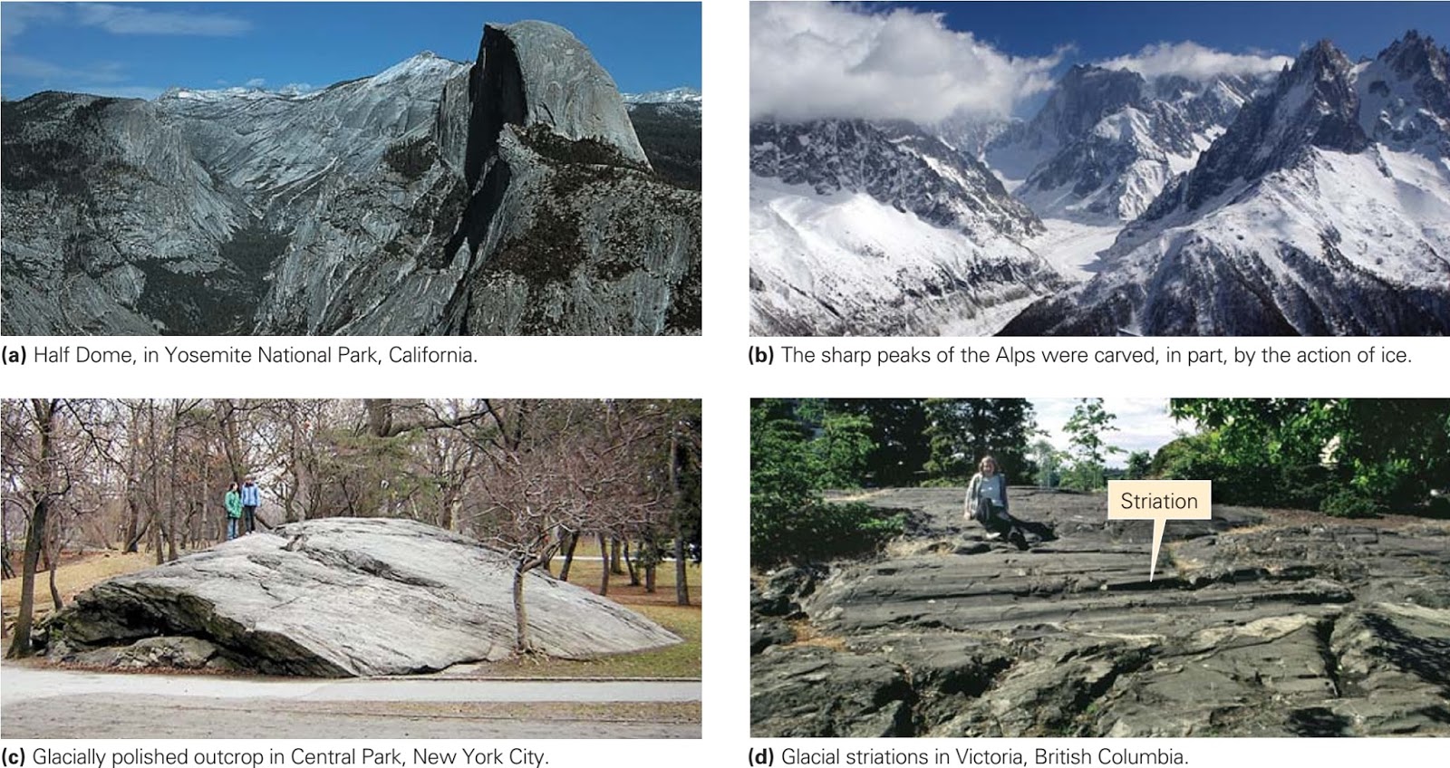
During the last ice age, valley glaciers cut deep, steep-sided valleys into the Sierra Nevada mountains of California. In the process, some granite domes were cut in half, leaving a rounded surface on one side and a steep cliff on the other. Half Dome, in Yosemite National Park, formed in this way (figure above a); its steep cliff has challenged many rock climbers. Such glacial erosion also produces the knife-edge ridges and pointed spires of high mountains (figure above b) and broad expanses where rock outcrops have been stripped of overlying sediment and polished smooth (figure above c). In many localities, the rock surface visible today is the same rock surface once in contact with ice. In some places, subsequent rockfalls and river erosion have substantially modified the surface.
As glaciers flow, clasts embedded in the ice act like the teeth of a giant rasp and grind away the substrate. This process, glacial abrasion, produces long gouges, grooves, or scratches called glacial striations (figure above d). Striations range from 1 cm to 1 m across and may be tens of centimeters to tens of meters long. As you might expect, striations run parallel to the flow direction of the ice. Rasping by embedded sand yields shiny glacially polished surfaces. 
Glaciers pick up fragments of their substrate in several ways. During glacial incorporation, ice surrounds debris so the debris starts to move with the ice. During glacial plucking (or glacial quarrying), a glacier breaks off fragments of bedrock. Plucking occurs when ice freezes around rock that has just started to separate from its substrate, so that movement of the ice can lift off pieces of the rock. At the toe of a glacier, ice may actually bulldoze sediment and trees slightly before flowing over them. 

Landscape features formed by the glacial erosion of a mountains landscape.
Let’s now look more closely at the erosional features associated with a mountain glacier (figure above a). Freezing and thawing during the fall and spring help fracture the rock bordering the head of the glacier (the ice edge high in the mountains). This rock falls on the ice or gets picked up at the base of the ice, and moves downslope with the glacier. As a consequence, a bowl-shaped depression, or cirque, develops on the side of the mountain. If the ice later melts, a lake called a tarn may form at the base of the cirque. The shape of a cirque may be maintained or even amplified by rockfalls after the glacier is gone. An arête (French for ridge), a residual knife-edge ridge of rock, separates two adjacent cirques. A pointed mountain peak surrounded by at least three cirques is called a horn. The Matterhorn, a peak in Switzerland, is a particularly beautiful example of a horn; each of its four faces is a cirque (figure above b).
Glacial erosion severely modifies the shape of a valley. To see how, compare a river-eroded valley with a glacially eroded valley. If you look along the length of a river in unglaciated mountains, you’ll see that it typically flows down a V-shaped valley, with the river channel forming the point of the V. The V develops because river erosion occurs only in the channel, and mass wasting causes the valley slopes to approach the angle of repose. But if you look down the length of a glacially eroded valley, you’ll see that it resembles a U, with steep walls. A U-shaped valley (figure above c) forms because the combined processes of glacial abrasion and plucking not only lower the floor of the valley but also bevel its sides.
Glacial erosion in mountains also modifies the intersections between tributaries and the trunk valley. In a river system, the trunk stream serves as the local base level for tributaries, so the mouths of the tributary valleys lie at the same elevation as the trunk valley. The ridges (spurs) between valleys taper to a point when they join the trunk valley floor. During glaciation, tributary glaciers flow down side valleys into a trunk glacier. But the trunk glacier cuts the floor of its valley down to a depth that far exceeds the depth cut by the tributary glaciers. Thus, when the glaciers melt away, the mouths of the tributary valleys perch at a higher elevation than the floor of the trunk valley. Such side valleys are called hanging valleys. The water in a post-glacial stream that flows down a hanging valley  cascades over a spectacular waterfall to reach the post-glacial trunk stream (figure above d). As they erode, trunk glaciers also chop off the ends of spurs (ridges) between valleys, to produce truncated spurs.

A roche moutonnée is an asymmetric bedrock hill shaped by the flow of glacial ice.
Now let’s look at the erosional features produced by continental ice sheets. To a large extent, these depend on the nature of the pre-glacial landscape. Where an ice sheet spreads over a region of low relief, such as the Canadian Shield, glacial erosion creates a vast region of polished, flat, striated surfaces. Where an ice sheet  spreads over a hilly area, it deepens valleys and smooths hills. Glacially eroded hills may end up being elongate in the direction of flow and may be asymmetric, for glacial rasping smoothes and bevels the upstream part of the hill, creating a gentle slope, whereas glacial plucking eats away at the downstream part, making a steep slope. Ultimately, the hill’s profile may resemble that of a sheep lying in a meadow such a hill is called a roche moutonnée, from the French for sheep rock (figure above a, b).

Fjords: Submerged Glacial Valleys 

One of the many spectacular fjords of Norway. The water is an arm of the sea that fills a glacially carved valley. Tourists are standing on Pulpit Rock (Prekestolen).
As noted earlier, where a valley glacier meets the sea, the glacier’s base remains in contact with the ground until the water depth exceeds about four-fifths of the glacier’s thickness, at which point the glacier floats. Thus, glaciers can carve U-shaped valleys even below sea level. In addition, during an ice age, water extracted from the sea becomes locked in the ice sheets on land, so sea level drops significantly. Therefore, the floors of valleys cut by coastal glaciers during the Pleistocene Ice Age were cut much deeper than present sea level. Today, the sea has flooded these deep valleys, producing fjords. In the spectacular fjord-land regions along the coasts of Norway, New Zealand, Chile, and Alaska, the walls of submerged U-shaped valleys rise straight from the sea as vertical cliffs up to 1,000 m high (figure above). Fjords also develop where an inland glacial valley fills to become a lake.
Credits: Stephen Marshak (Essentials of Geology)

Ice and the Nature of Glaciers

Ice and the Nature of Glaciers 

What Is Ice? 

The nature of ice and the formation of glaciers. Snow falls like sediment and metamorphoses to ice when buried.
Ice consists of solid water, formed when liquid water cools below its freezing point. We can apply concepts introduced in our earlier discussions of rocks and minerals to distinguish among various occurrences of ice. For example, we can think of a single ice crystal as a mineral specimen, for it is a naturally occurring, inorganic solid, with a definite chemical composition (H2O) and a regular crystal structure. Ice crystals have a hexagonal form, so snowflakes grow into six-pointed stars (figure above a). We can picture a layer of fresh snow as a layer of sediment, and a layer of snow that has been compacted so that the grains stick together as a layer of sedimentary rock (figure above b). We can also think of the ice that appears on the surface of a pond as an igneous rock, for it forms when molten ice (liquid water) solidifies. Glacial ice, in effect, is a metamorphic rock. It develops when pre-existing ice recrystallizes in the solid state, meaning that the molecules in solid water rearrange to form new crystals (figure above c).

How a Glacier Forms 

In order for a glacier to form, three conditions must be met. First, the local climate must be cold enough that winter snow does not melt entirely away during the summer. Second, there must be sufficient snowfall for a large amount of snow to accumulate. And third, the slope of the surface on which the snow accumulates must be gentle enough that the snow does not slide away in avalanches, and must be protected enough that the snow doesn't blow away. 
Glaciers develop in polar regions because, even though relatively little snow falls today, temperatures remain so cold that most ice and snow survive all year. Glaciers develop in mountains, even at low latitudes, because temperature decreases with elevation; at high elevations, the mean temperature stays cold enough for ice and snow to survive all year. Since the temperature of a region depends on latitude, the specific elevation at which mountain glaciers form also depends on latitude. In Earth’s present-day climate, glaciers form only at elevations above 5 km at the equator, but can flow down to sea level at  latitudes of between 60 and 90 degrees. 
The transformation of snow to glacier ice takes place as younger snow progressively buries older snow. Freshly fallen snow consists of delicate hexagonal crystals with sharp points. The crystals do not fit together tightly, so fresh snow contains about 90% air. With time, the points of the snowflakes become blunt because they either sublimate (evaporate directly into vapour) or melt, and the snow packs more tightly. As snow becomes buried, the weight of the overlying snow increases pressure, which causes remaining points of contact between snowflakes to melt. Gradually, the snow transforms into a packed granular material called firn, which contains only about 25% air (figure above d). Melting of firn grains at contact points produces water that crystallizes in the spaces between grains until eventually the firn transforms into a solid mass of glacial ice composed of interlocking ice crystals. Such glacial ice, which may still contain up to 20% air trapped in bubbles, tends to absorb red light and thus has a bluish colour. The transformation of fresh snow to glacier ice can take as little as tens of years in regions with abundant snowfall, or as long as thousands of years in regions with little snowfall. 

Categories of Glaciers 

Glaciers are streams or sheets of recrystallized ice that stay frozen all year long and flow under the influence of gravity. Today, they highlight coastal and mountain scenery in Alaska, the Cordillera of western North America, the Alps of Europe, the Southern Alps of New Zealand, the Himalayas of Asia, and the Andes of South America, and they cover most of Greenland and Antarctica. Geologists distinguish between two main categories: mountain glaciers and continental glaciers. 

A great variety of glaciers form in mountainous areas.
Mountain glaciers (also called alpine glaciers) exist in or adjacent to mountainous regions (figure above a). Topographical features of the mountains control their shape; overall, mountain glaciers flow from higher elevations to lower elevations. Mountain glaciers include cirque glaciers, which fill bowl-shaped depressions, or cirques, on the flank of a mountain; valley glaciers, rivers of ice that flow down valleys; mountain ice caps, mounds of ice that submerge peaks and ridges at the crest of a mountain range; and piedmont glaciers, fans or lobes of ice that form where a valley glacier emerges from a valley and spreads out into the adjacent plain (figure above b–d). Mountain glaciers range in size from a few hundred meters to a few hundred kilometres long.

Antarctica is an ice-covered continent.
Continental glaciers are vast ice sheets that spread over thousands of square kilometres of continental crust. Continental glaciers now exist only on Antarctica and Greenland (figure above a, b). Antarctica is a continent, so the ice beneath the South Pole rests mostly on solid ground. Locally, however, lakes of liquid water exist at the base of continental glaciers. In 2012, Russian geologists drilled into one of these lakes, Lake Vostock, 3.7 km below the surface of the Antarctic ice sheet. Continental glaciers flow outward from their thickest point (up to 3.5 km thick) and thin toward their margins, where they may be only a few hundred meters thick. 
Geologists also find it valuable to distinguish between types of glaciers on the basis of the thermal conditions in which the glaciers exist. Temperate glaciers occur in regions where atmospheric temperatures become warm enough for the glacial ice to be at or near its melting temperature during part or all of the year. Polar glaciers occur in regions where atmospheric temperatures stay so cold all year long that the glacial ice remains below melting temperature throughout the year. Of note, Earth is not alone in hosting polar glaciers Mars has them too (read below). 

Polar Ice Caps on Mars

The ice caps of Mars.
Mars has white polar ice caps that change in area with the season, suggesting that they partially melt and then refreeze (figure above a, b). The question of what the ice caps consist of remained a puzzle until fairly recently. It now appears that the Martian ice caps consist mostly of water (H2O) ice mixed with a small amount of dust. The ice caps attain a maximum thickness of 3 km. During the winter, atmospheric carbon dioxide freezes and covers the north polar cap with a 1-m-thick layer of frozen CO2 (dry ice). During the summer, this layer melts away. The south polar cap has a dry-ice blanket that is 8 m thick and doesn't melt away entirely in the summer. The difference between the north and south poles may reflect elevation, for the south pole is 6 km higher and therefore remains colder. 
High-resolution photographs reveal that distinctive canyons, up to 10 km wide and 1 km deep, spiral outward from the centre of the north polar ice cap. Why did this  pattern form? Recent calculations suggest that if the ice sublimates (transforms into gas) on the sunny side of a crack and refreezes on the shady side, the crack will migrate sideways over time. If the cracks migrate more slowly closer to the pole, where it’s colder, than they do farther away, they will naturally evolve into spirals.

The Movement of Glacial Ice 

How do glaciers move? Let’s consider the two mechanisms that allow glaciers to move plastic deformation and basal sliding. At conditions found below depths of about 60 m in a glacier, ice deforms by plastic deformation, meaning that the grains within it change shape very slowly, and new grains grow while old ones disappear. We can picture such changes to be a consequence of the rearrangement of water molecules within ice grains. If ice is warm enough for thin water films to form along grain boundaries, plastic deformation may also involve the microscopic slip of ice grains past their neighbours along the water films. In cases where significant quantities of meltwater accumulate at the base of a glacier, forming a layer either of liquid or of slurry like wet sediment, glaciers can move by basal sliding. During this process, the liquid water or water-saturated slurry layer holds the glacial ice above bedrock and thereby decreases friction; effectively, the glacier glides along on a wet cushion. 

Crevasses form in the upper layer of a glacier, in which the ice is brittle. Commonly, cracking takes place where the glacier bends while flowing over steps or ridges in its substrate.
As we noted earlier, plastic deformation takes place only at depths of greater than about 60 m in a glacier above this depth, known as the brittle–plastic transition, ice is too brittle to flow. As a glacier overall undergoes movement, its upper 60 m of ice deforms predominantly by cracking. A crack that develops by brittle deformation of a glacier is called a  crevasse (figure above). In large glaciers, crevasses can be hundreds of meters long, and they can open up to form open gashes up to 15 m across. 

Forces that drive the movement of glaciers.
Why do glaciers move? Ultimately, because the pull of gravity is strong enough to make ice flow (figure above a, b). A glacier flows in the direction in which its top surface slopes. Thus, valley glaciers flow down their valleys, and continental ice sheets spread outward from their thickest point. To picture the movement of a continental ice sheet, imagine pouring honey on a tabletop. The honey spreads out until the puddle reaches an even thickness. In the case of a continental ice sheet, a thick pile of ice builds up, and gravity causes the top of the pile to push down on the ice at the base. Eventually, the basal ice can no longer support the weight of the overlying ice and begins to deform plastically. When this happens, the basal ice starts squeezing out to the side, carrying the overlying ice with it. The greater the volume of ice that builds up, the wider the ice sheet can become. 

Flow velocities vary with location in a glacier. Overall, ice flows from the zone of accumulation to the zone of  toe.
Glaciers generally flow at rates of between 10 and 300 m per year. Not all parts of a glacier move at the same rate. For example, friction between rock and ice slows a glacier, so the centre of a valley glacier moves faster than its margins, and the top of a glacier moves faster than its base (figure above a, b). If water builds up beneath a valley glacier to the point where it lifts the glacier off its substrate, basal sliding starts and the glacier undergoes a glacial surge. During surges, glaciers have been clocked at speeds of 10 to 110 m per day! Sudden surges may generate ice quakes, whose seismic vibrations travel through the glacier and through the rock below.

Glacial Advance and Retreat 

Glaciers resemble bank accounts: snowfall accumulates and adds to the account, while ablation the removal of ice by sublimation (the evaporation of ice into water vapour), melting (the transformation of ice into liquid water, which flows away), and calving (the breaking off of chunks of ice) subtracts from the account. Snowfall adds to the glacier in the zone of accumulation, whereas ablation subtracts in the zone of ablation; the boundary between these two zones is the equilibrium line. 

Glacial advancement and retreat.
The leading edge or margin of a glacier is called its toe, or terminus (figure above a). If the rate at which ice builds up in the zone of accumulation exceeds the rate at which ablation occurs below the equilibrium line, then the toe moves forward into previously unglaciated regions. Such a change is called a glacial advance (figure above b). In mountain glaciers, the position of a toe moves downslope during an advance, and in continental glaciers, the toe moves outward, away from the glacier’s origin. If the rate of ablation below the equilibrium line equals the rate of accumulation, then the position of the toe remains fixed. But if the rate of ablation exceeds the rate of accumulation, then the position of the toe moves back toward the origin of the glacier; such a change is called a glacial retreat (figure above c). During a mountain glacier’s retreat, the position of the toe moves upslope. It’s important to realize that when a glacier retreats, it’s only the position of the toe that moves back toward the origin, for ice continues to flow toward the toe. Glacial ice cannot flow back toward the glacier’s origin. 
One final point before we leave the subject of glacial flow: beneath the zone of accumulation, a volume of ice gradually moves down toward the base of the glacier as new ice accumulates above it, whereas beneath the zone of ablation, a volume of ice gradually moves up toward the surface of the glacier, as overlying ice ablates. Thus, as a glacier flows, ice volumes follow curved trajectories (figure above a–c). For this reason, rocks picked up by ice at the base of the glacier may slowly move to the surface. 

Ice in the Sea 

On the moonless night of April 14, 1912, the great ocean liner Titanic struck a large iceberg in the frigid North Atlantic. Lookouts had seen the ghostly mass of frozen water only minutes earlier and had alerted the ship’s pilot, but the ship had been unable to turn fast enough to avoid disaster. The force of the blow split the steel hull, allowing water to gush in. Less than 3 hours later, the ship disappeared beneath the surface, and 1,500 people perished. 

Ice shelves, tidewater glaciers, and sea ice, the nature of coastal areas in glacial regions.
Where do icebergs, such as the one responsible for the Titanic’s demise, originate? In high latitudes, mountain glaciers and continental ice sheets flow down to the sea, and they either stop at the shore or flow into the sea. Glaciers whose terminus lies in the water are called tidewater glaciers. Valley glaciers may protrude farther into the ocean to become ice tongues. Continental glaciers entering the sea become broad, flat sheets known as ice shelves. In shallow water, glacial ice remains grounded (figure above a). But where the water becomes deep enough, the ice floats with four-fifths of the ice below the water’s surface. At the boundary between glacier and ocean, blocks of ice calve off and tumble into the water with an impressive splash. If a free-floating chunk rises 6 m above the water and is at least 15 m long, it is formally called an iceberg. Since four-fifths of the ice lies below the surface of the sea, the base of a large iceberg may actually be a few hundred meters below the surface (figure above b, c). 
Not all ice floating in the sea originates as  glaciers on land. In polar climates, the surface of the sea itself freezes, forming sea ice (figure above d). The north polar ice cap of the Earth consists of sea ice, formed on the surface of the Arctic Ocean. Some sea ice, such as that covering the interior of the Arctic Ocean, floats freely; but some protrudes outward from the shore. Vast areas of ice shelves and of sea ice have been disintegrating in recent years. For example, ice-free openings develop in the Arctic Ocean sea ice during the summers, and the area of the ice shelf in Antarctica has been decreasing rapidly. 
Credits: Stephen Marshak (Essentials of Geology)

الخميس، 20 أغسطس 2015

Alpine Glacier Basics


Interested for our works and services?
Get more of our update !