صور المظاهر بواسطة MichaelJay. يتم التشغيل بواسطة Blogger.
أقسام المدونة :

السبت، 2 مايو 2015

The most active volcanic region on Earth

Most active Volcanic Region

Iceland is the most active volcanic region on Earth located in the Atlantic ocean between Greenland and Norway. It is a landmass that is part of a much larger entity situated at the junction of two large submarine structures, the Mid-Atlantic ridge and the Greenland-Iceland Faeroes Ridge. Iceland is located where the Asthenospheric flow under the north east Atlantic plate boundary interacts and mixes with a deep seated mantle plume. The buoyancy of the Iceland plume leads to dynamic uplift of the Iceland plateau and high volcanic productivity over the plume produces a thick crust.
Iceland is one of the most active volcanic regions on Earth where almost all types of volcanic and geothermal activity can be found. The volcanism on Iceland is the contribution from both the Iceland plume hotspot activity and the Mid Atlantic Ridge activity. The Mid Atlantic Ridge as the name indicates is the ridge forming from volcanism in Atlantic ocean but however it is also visible on land. Iceland's landscapes are forged by the processes of volcanism. The volcanic landscapes include rift valleys, geysers, hot springs, rhyolite mountains, columnar basalt formations, lava fields and lunar like craters. Subglacial volcanism has created table mountains in northern and southern Iceland. Iceland sits spanning the Mid Atlantic Ridge tectonic plate boundary which separates the Eurasian and the North American plates. The ridge, and underwater mountain chain extended about 16,000 km along the north-south axis of the Atlantic ocean. A rift valley running along its spine is formed by plate tectonics and it's the locus of new crust formation. Molten lava from beneath the Earth's crust constantly comes up, cools and is pushed away from the ridge flanks which widen the gap between continents in the process. Iceland formed by the coincidence of the spreading boundary of the North American and Eurasian plate with a hotspot or mantle plume. As the plates moved apart, excessive eruptions of lava constructed volcanoes and filled the rift valleys. Subsequent movement rifted these later lava fields causing long valleys bounded by parallel faults. The divergence of the ridge started in the north about 150 million years ago and 90 million years ago in the south. These movements continue today accompanied by earthquake, reactivation of old volcanoes and creation of new ones. 

Stokkur Geyser, Iceland
Strokkur is located less than 100 metre away from Geysir and it erupts frequently every 4 to 8 minutes. Strokkur is a fountain geyser. It is one of the very few geysers that erupts regularly spouting steaming water up to 20 meters. 

Why do geysers occur?

Well geysers occur in high temperature geothermal areas within the zone of active rifting and volcanism where temperature in the subsurface sis higher than 200 Celsius at less than 1 km depth. The temperature of the hot springs is up to 100 Celsius and some are constantly boiling. If the temperature at depth rises above boiling, the hot springs erupt which means that they are geysers. Geysers eruption occurs when boiling water within the geyser trapped by cooler water above it explodes forcing its way to the surface.

Katla volcano, Iceland
Katla volcano is located near the southern end of Iceland's eastern volcanic zone and is hidden beneath the Myrdalsjökull icecap. Katla is one of Iceland's most active and most dangerous volcanoes, infamous for its large eruptions happening on average every 50-100 year causing devastating glacial floods. Well its been quiet now for a long time but in recent year, increased seismicity and inflation of Katla has been measured. Katla statistically due for a new eruption but an eruption is not too distant would not come as a big surprise.

الجمعة، 1 مايو 2015

Hawaiian islands can exceed the current count

Hotspot
Hotspots or hot spots are region of active volcanism where mantle feeds the hotspot with magma. The magma rise in the hotspot from mantle to crust. It readily meets the crustal plates and as hotspot comprises of hot magma, it starts to melt the above lying crustal rocks. Some areas can be easily accessed by magma as rocks are not hard enough that can bear the hot magma and doesn't rapidly melt and some rocks can be melted easily. Several minerals have high melting point while some have low. This melting point of minerals suggest the rock either to quickly melt or takes time to break the point. When magma start melting so it rises into the crustal rocks. Some places takes little time to break and magma rises to the surface. This is just the case of the Hawaiian islands where static hotspot point is below the islands.
Hawaiian islands
The Hawaiian Islands are at the south eastern end of a chain of volcanoes that began to form more than 70 million years ago. Many of these volcanoes formed islands that have subsided and eroded beneath sea level, and some of the old volcanoes probably never reached sea level. Each Hawaiian island is made of one or more volcanoes, which first erupted on the sea floor and only emerged above the ocean's surface after countless eruptions. As there are series of islands comprises collectively of Hawaiian. All islands are the result from a single static hotspot. The hotspot feeds the surface with lava which starts to build a ridge. The ridge when fed a lot rises above the surface water and form an island. Well how does series of islands have formed with some distance?.
This can be understood by plates drifting. Hawaiian islands are on pacific plate that is most active oceanic plate. As a a ridge reaches the surface and makes an island, due to the Pacific plate movement it drifted away from the hotspot. The hotspot magma rise to the surface again by breaking the plate and starting building again an island which was then drifted away so the series of Hawaiian islands formed. 
The Hawaiian islands forming hotspot is still active and as of the Pacific plate movement. This will allow the generation of more islands adding to the Hawaiian series.

الأربعاء، 29 أبريل 2015

San Andreas fault can still hit major earthquake

San Andreas Fault

San Andreas fault aerial view
San Andreas fault is a continental transform fault extended over an area approximately 810 miles through California state. It is a right lateral strike slip fault with plate boundary with Pacific plate and North American plate. The fault has three segments where each segment has different characteristics and can originate a different degree of earthquake risk. The most significant being the southern part because it passes through 35 miles of Los Angeles. The name San Andreas is from the San Andreas lake which is a small body of water that was formed in a valley between the two plates. Transform fault is the sliding boundary between two plates. In San Andreas fault there are much of the fractures and faults associated with it which marks the zone where these two plates meet. San Andreas fault is about 28 years old when these plates first interacted. These plates are slowly moving along each other.


San Andreas fault map showing locked and creeping zones
The two plates are siding with each other at the rate of a couple inches through the year. This rate of movement is spectacular and can develop significant amount of strain with the boundary of the two plates. As shown in the photograph, there are areas which are marked red that is locked down and no movement is along them nowadays and the blue shows the moving area of the fault. As the locked up places does feel the stress but due to stuck plates, no movement is being caused in these areas. But this will never be the same but instead when stress is greater then it can accommodate, one day it will show abrupt movement as was in 1906 earthquake when sudden movement was approximately 21 feet on the areas which were locked. Lets have a look back at the earthquakes generated by the San Andreas fault preserved in the history. 

Earthquakes from the San Andreas fault

The first recorded earthquake from the San Andreas fault is in 1769 then was in December 8. 1812 killing forty persons. Later in January. 1857 which was severe shock then is in October, 1868 killing thirty persons. Then is in March 1872, killed 27 people and on April 19, 1892 Vacaville was damaged. On Christmas day in 1899 six person died because of earthquake from San Andreas. Then the giant earthquake of April 18, 1906 which killed 700 people including total damage of $500 million. Damage of $1 million was done by June 22, 1915 earthquake $200,000 in April 1918. Other are in June 1925 with damage of $8 million, November, 1927 earthquake, March 1933, May 1940 and July 1952. All earthquakes were severe some more and some less damage causing. 

Latest study of the San Andreas fault

Of the hundreds of seismogenic (earthquake causing) geologic faultsin California, UCERF (Uniform California Earthquake Rupture Forecast) classifies only six faults as Type A sources, meaning there is sufficient information to both estimate and model the probability of a Magnitude (M) 6.7 or greater earthquake within 30 years. These six faults are the: (1) San Andreas (split into northern and southern sections, (2) San Jacinto, (3) Elsinore, (4) Garlock, (5) Calaveras, and (6) Hayward-Rodgers Creek. Faults which are known to be slipping (and therefore seismogenic) but lack sufficient information to fully model how close they might be to rupture are classified as Type B. About twenty of these faults are estimated to have a 5% or greater chance of an M ≥ 6.7 earthquake within 30 years. An additional six areas where strain is accumulating but where knowledge is insufficient to apportion slip onto specific faults are classified as Type C sources.

There is additional chance of earthquakes on faults that were not modeled, and of lesser earthquakes. Northern California has an estimated 12% chance over the same 30 years of an M ≥ 8 mega thrust earthquake on the Cascadia subduction zone. UCERF has also prepared "participation probability maps" of the chance that any area will experience an earthquake above a certain magnitude from any source in the next 30 years.

الأحد، 26 أبريل 2015

Indian plate is on the move

Indian plate movement

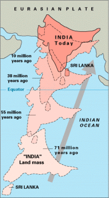
Indian plate as parted from the Australian plate and moved north towards Eurasian plate 130 million years ago. The Indian plate moved northwards as continents drifts so it collided with Eurasian plate which was already present in the north. From the day of collision the movement of the Indian plate hasn't stopped, slowly and gradually momentum continues. The rate of Indian plate movement is 45 millimetres a year nowadays. As it is convergent plate boundary which is also termed as destructive plate boundary because of no basinal development but instead are the collision where mountain building takes part. Himalayas ranges are the resulting Eurasian and Indian plate collisions. As the movement continued there are more ranges and thrust faults resulted from it. Indian plate cannot compete with that of a more massive Eurasian plate so lifting will be the result when Indian plate progresses, so it breaks making thrust faults. 
So what basically is the reason to discuss the Indian plate movement?
Well the answer is the faults in the Indian plate as a result of its northwards progression. 7.8 magnitude earthquake struck Nepal which was devastating. A lot of life were taken because of the ground shaking in Nepal capital Kathmandu.This earthquake was result of the fault line beneath the two plates meeting point, Himalayas. As plates movements are sometime stopped a while because of the plate edges being stuck into one another. The reason for the edges stuck is the brittle rocks which are hard enough not to break but instead stuck. When the plate moves its edges got friction as rocks are stuck, gives a jerk which results in the earthquakes. 
Nepal earthquake

Nepal earthquake
So this time Nepal is on the hit because of the earthquake caused from the Indian plate movement. Aftershocks are always coming from a major earthquakes, how much more lives are at stake from it? the number up till now is said to be 1500 from the officials but it will still grow as aftershocks continued. 

الخميس، 23 أبريل 2015

Calbuco volcano, Chile volcanic activity

Calbuco volcano, Chile


As recent activity in Chile regarding active volcanism suggests that it is indeed the recent most active magmatesim. On 3rd March it was reported volcanic activity from Villarrica volcano which erupted with fumes and magma in the air. Villarica is situated in the south of Chile with that of Calbuco in south too. 
Calbuco volcano, Chile
That Calbuco volcano hasn't erupted in the last 42 years up till now. It was last erupted in 1961. The Calbuco volcano erupted twice the same day. First eruption was followed by another a few hours later. Well there hasn't been any magma coming out of the volcano but the ash and smoke shot into the sky several kilometres. Calbuco volcano is situated in the south of capital Santiago in a tourist location, Peurto Varas. An area of 20 kilometres is suggested to evacuate for the safety of people but the other dangers are also present as that, if the volcano start lava eruption then melting ice will follow flooding in the area. A strange phenomenon always occur with the eruption where weather is responsible for the thunderstorm with volcanic eruption. Most probably there will be more volcanic eruption followed into the area after the recent two, Villarica and Calbuco.

الأربعاء، 22 أبريل 2015

Hydraulic fracturing or fracking

Hydraulic fracturing

Hydraulic fracturing also referred as hydrofracturing, hydrofracking, fracking or fraccing is a well stimulation technique in which rock is fractured by a hydraulically pressurized liquid made of water, sand and chemicals. Hydraulic fracturing is just like a dyke or sill formed in a rock where the hot magma intrudes and fractures the host rock. In hydraulic fracturing pressurized fluid is injected into the well bore hole to create cracks in the deep rock formations. The cracks or fractures in the formation of interest where oil and gas exists will more freely flow through the cracks. As the pressure is then removed from the well to extract the oil and gas, some of the hydraulic fracturing proppants is still in the fractures which don't allow the formation to close down and fractures remain open. 

Risks in hydraulic fracturing

As hydraulic fracturing is the technique which allows large number of oil and gas reserves extraction which are not accessible because of the low permeability of the formation bearing oil and gas. There are a lot of arguments regarding hydraulic fracturing. The environmental impacts of hydraulic fracturing includes the contamination of ground water, depleting fresh water, degrading air quality, potentially triggered earthquakes, noise pollution, surface pollution and the consequential hazard to public health and environment. Increase in seismic activity following hydraulic fracturing along dormant or previously unknown faults are sometimes caused by the deep injection disposal of hydraulic fracturing flow back and produced formation brine (a byproduct of both fractured and nonfractured oil and gas wells).

Advantages and disadvantages of fracking

Fracking has an advantage that it fractures the formation so that more and more oil and gas recovery can be done in a less time consuming allowing more permeability in the formation.
The disadvantage is also of the very much concerns as much damage can be to the planet. Air to water freshness lost and also triggering earth quakes.

Oklahoma earthquakes from the fracking

Oklahoma state had an average rate of earthquakes in the back year at 2008, the average rate of earthquakes of magnitude 3.0 was 2 per year. As hydraulic fracturing technique was in use for hydrocarbon recovery, increased to count of 109 in 2013. Prior to that last year it was recorded about 585 earthquakes.

الاثنين، 13 أبريل 2015

Quartzite


What is Quartzite?

Quartzite is a nonfoliated metamorphic rock that formed by the metamorphism of pure quartz sandstone. The intense heat and pressure of metamorphism causes the quartz grains to compact and become tightly intergrown with each other, resulting in very hard and dense quartzite. The name quartzite implies not only a high degree of induration (hardness), but also a high quartz content. Quartzite generally comprises greater than 90% percent quartz, and some examples, containing up to 99% quartz, and are the largest and purest concentrations of silica in the Earth's crust. Although a quartz-rich sandstone can look similar to quartzite, a fresh broken surface of quartzite will show breakage across quartz grains, whereas the sandstone will break around quartz grains. Quartzite also tends to have a sugary appearance and glassy lustre.
When sandstone is cemented to quartzite, the individual quartz grains recrystallise along with the former cementing material to form an interlocking mosaic of quartz crystals. Most or all of the original texture and sedimentary structures of the sandstone are erased by the metamorphism. The grainy, sandpaper-like surface becomes glassy in appearance. Minor amounts of former cementing materials, iron oxide, silica, carbonate and clay, often migrate during crystallisation and metamorphosis. This causes streaks and lenses to form within the quartzite.

Orthoquartzite is a very pure quartz sandstone composed of usually well-rounded quartz grains cemented by silica. Orthoquartzite is often 99% SiO2 with only very minor amounts of iron oxide and trace resistant minerals such as zircon, rutile and magnetite. Although few fossils are normally present, the original texture and sedimentary structures are preserved.
The term is also traditionally used for quartz-cemented quartz arenites, and both usages are found in the literature. The typical distinction between the two (since each is a gradation into the other) is a metamorphic quartzite is so highly cemented, diagenetically altered, and metamorphosized so that it will fracture and break across grain boundaries, not around them.

Quartzite is very resistant to chemical weathering and often forms ridges and resistant hilltops. The nearly pure silica content of the rock provides little for soil; therefore, the quartzite ridges are often bare or covered only with a very thin layer of soil and (if any) little vegetation.

Occurrences

In the United States, formations of quartzite can be found in some parts of Pennsylvania, eastern South Dakota, Central Texas, southwest Minnesota, Devil's Lake State Park in the Baraboo Range in Wisconsin, the Wasatch Range in Utah, near Salt Lake City, Utah and as resistant ridges in the Appalachians and other mountain regions. Quartzite is also found in the Morenci Copper Mine in Arizona. The town of Quartzsite in western Arizona derives its name from the quartzites in the nearby mountains in both Arizona and Southeastern California. A glassy vitreous quartzite has been described from the Belt Supergroup in the Coeur d’Alene district of northern Idaho.

In the United Kingdom, a craggy ridge of quartzite called the Stiperstones (early Ordovician – Arenig Epoch, 500 Ma) runs parallel with the Pontesford-Linley fault, 6 km north-west of the Long Mynd in south Shropshire. Also to be found in England are the Cambrian "Wrekin quartzite" (in Shropshire), and the Cambrian "Hartshill quartzite" (Nuneaton area).[15] In Wales, Holyhead mountain and most of Holy island off Anglesey sport excellent Precambrian quartzite crags and cliffs. In the Scottish Highlands, several mountains (e.g. Foinaven, Arkle) composed of Cambrian quartzite can be found in the far north-west Moine Thrust Belt running in a narrow band from Loch Eriboll in a south-westerly direction to Skye. In Ireland areas of quartzite are found across the northwest, with Mount Errigal in Donegal as the most prominent outcrop.

In Canada, the La Cloche Mountains in Ontario are composed primarily of white quartzite. The highest mountain in Mozambique, Monte Binga (2436 m), as well as the rest of the surrounding Chimanimani Plateau are composed of very hard, pale grey, precambrian quartzite. Quartzite is also mined in Brazil for use in kitchen countertops.

Physical Properties of Quartzite

Quartzite is usually white to gray in color. Some rock units that are stained by iron can be pink, red, or purple. Other impurities can cause quartzite to be yellow, orange, brown, green, or blue.
The quartz content of quartzite gives it a hardness of about seven on the Mohs Hardness Scale. Its extreme toughness made it a favourite rock for use as an impact tool by early people. Its conchoidal fracture allowed it to be shaped into large cutting tools such as ax heads and scrapers. Its coarse texture made it less suitable for producing tools with fine edges such as knife blades and projectile points.

Where Does Quartzite Form?

Most quartzite forms during mountain-building events at convergent plate boundaries. There, sandstone is metamorphosed into quartzite while deeply buried. Compressional forces at the plate boundary fold and fault the rocks and thicken the crust into a mountain range. Quartzite is an important rock type in folded mountain ranges throughout the world.

Quartzite as a Ridge-Former

Quartzite is one of the most physically durable and chemically resistant rocks found at Earth's surface. When the mountain ranges are worn down by weathering and erosion, less-resistant and less-durable rocks are destroyed, but the quartzite remains. This is why quartzite is so often the rock found at the crests of mountain ranges and covering their flanks as a litter of scree.
Quartzite is also a poor soil-former. Unlike feldspars which break down to form clay minerals, the weathering debris of quartzite is quartz. It is therefore not a rock type that contributes well to soil formation. For that reason it is often found as exposed bedrock with little or no soil cover.

How the Name "Quartzite" Is Used

Geologists have used the name "quartzite" in a few different ways, each with a slightly different meaning. Today most geologists who use the word "quartzite" are referring to rocks that they believe are metamorphic and composed almost entirely of quartz.
A few geologists use the word "quartzite" for sedimentary rocks that have an exceptionally high quartz content. This usage is falling out of favor but remains in older textbooks and other older publications. The name "quartz arenite" is a more appropriate and less confusing name for these rocks.
It is often difficult or impossible to differentiate quartz arenite from quartzite. The transition of sandstone into quartzite is a gradual process. A single rock unit such as the Tuscarora Sandstone might fully fit the definition of quartzite in some parts of its extent and be better called "sandstone" in other areas. Between these areas, the names "quartzite" and "sandstone" are used inconsistently and often guided by habit. It is often called "quartzite" when rock units above and below it are clearly sedimentary. This contributes to the inconsistency in the ways that geologists use the word "quartzite."

Uses of Quartzite

Because of its hardness and angular shape, crushed quartzite is often used as railway ballast.Quartzite is a decorative stone and may be used to cover walls, as roofing tiles, as flooring, and stairsteps. Its use for countertops in kitchens is expanding rapidly. It is harder and more resistant to stains than granite.Crushed quartzite is sometimes used in road construction. High purity quartzite is used to produce ferrosilicon, industrial silica sand, silicon and silicon carbide. During the Paleolithic quartzite was used, in addition to flint, quartz, and other lithic raw materials, for making stone tools.

Interested for our works and services?
Get more of our update !