صور المظاهر بواسطة MichaelJay. يتم التشغيل بواسطة Blogger.
أقسام المدونة :

الأحد، 21 سبتمبر 2014

Paleontology

Paleontology is the study of fossils. Fossils are any remains of the organism lived and preserved on this Earth by millions of years ago. Any organism from large to micro level are the part of paleontology. The history of earth is preserved in these fossils. Our generation haven't seen any dinosaurs but it is the fact lived million years ago. These fossils are the key to study earth from its beginning. There were many creatures lived on this earth which are extinct but their fossils preserved and discovered reveals the history. These remains are studied under paleontology
Types of paleontology includes vertebrates and invertebrates

Vertebrates paleontology

Vertebrates are organism that have backbone. Backbone presence shows that organism have skeletal remains. Skeleton is the hard part of an organism which are preserved through years and are now studied. As the soft parts of organism are decayed through time but hard skeleton preserved are discovered.

Invertebrates

There are many organism which do not have backbone hence do not have skeleton in them but there are hard parts of an organism which are preserved. Shell remains which are made of mostly silicates and calcium are preserved. The remaining body can be assumed and studied.

This study helps in examining and interpreting creature habitat, body functions and food consumption.

الجمعة، 19 سبتمبر 2014

Sedimentology

Sedimentology is the study of processes which are formation, transportation and deposition of sediments of continents as well the marine environments which forms the sedimentary rocks.

Sedimentary processes

Sedimentary rock natures varies with difference of the grains origin, size, shape and composition. Grains and pebbles particles may be derived from the erosion of existing rocks or from volcanic eruption. Organism also contributes to sediments which varies from micro organism to reefs. These have calcium carbonate shells which rest at floors to make sedimentary rock, limestone. Sedimentary rock formation involves transportation which can be aided by any of the medium air, water, ice, gravity or chemical, biological growth of sediments at depositional site. Few factor influence the accumulation of sediments ultimate results on the formation of rock which are chemistry, temperature and biological characteristics of desired location. Transportation and depositional processes can be interpretted by looking at the sediments layers, their size, shape and distribution pattern gives knowledge of the processes of transportation. Sedimentary structures also proves the type of transportation medium example ripple marks. As present is the key to past so keeping this in mind physical, chemical and biological characters of the sedimentary rock can be examined to interpret the sedimentation process which resulted the formation of rock. 

Sedimentary environment and facies

Every environment have its own characteristics either chemical, biological or physical. Studying these properties of the sedimentary rocks deposited and exposed on the surface reveals the secrets of environments at which they deposited. As an example of the fluvial environment, river base deposits will have gravely sandy material deposited while in floods on the banks of the river fine sediments will deposits providing habitat to vegetation. The channel will have lens of sand or conglomerate while the floodplain will have clay producing mud rock and sand at the base.
As every environment has own characteristic rocks so these are termed facies. Facies is a rock body with specific characteristics that reflects the condition under which it formed. For describing a facie its all characteristics as lithology, texture, sedimentary structures and fossil content are documented in order to fully interpret its environment of deposition. 

الأربعاء، 17 سبتمبر 2014

Ore forming processes

Ore is a rock body that is enriched in one or more minerals.

Ore forming processes

Magmatic process

Magmatic is when liquid magna cools and solidifies to form igneous rock, it forms ore of metals, gems and other precious resources.

Layered plutons

Magma of the mafic nature solidifies in layers. Every layer has different mineralization. Some layers may have rich deposits. There are three type of processes which produces layered plutons
  • As magma solidifies (plutonic) its temperature gradually decreases. Minerals crystalize first in the liquid magma. Some crystals are denser than the magma which will settle down and is concentrated at the bottom which is also called crystal settling.
  • In the mafic magma crystallization usually starts from the bottom so early forming minerals are concentrated at the base.
  • When these processes occur and form minerals, at some time different magma can enter these mineraliztion which can change the early minerals formed.

Kimberlites

Kimberlites are igneous rocks that are produced in the mantle and are the main diamonds source.

Volcanic vent deposits

Volcanic vent deposits are from the gases escaping from the volcano where it precipitates such as sulphur. Sulphur usually deposits as a pure yellow deposition from the escaping gases and are used in sulphuric acid manufacturing.

Hydrothermal process

Hydrothermal process is the most common ore forming process. Water is heated by the magma chamber and this water dissolves metals. Metals are dissolved in the water and this solution seeps through cracks, fractures and through permeable rocks until they are precipitated and form a deposit. There are three types of water sources
  • Magmas of granitic composition when solidifies leaves a water-rich residual fluid which precipitates and form ore body.
  • In active volcanic activities when ground water seeps down through the crust, these magma chamber heats the water which provides the hydrothermal solution. This hydrothermal solution is at shallow depths and its precipitation makes an ore.
  • Sea water is heated when it seeps along cracks in the oceanic crust mostly at the mid oceanic ridges and submarine volcanoes. 
As of the fact that salty water increases the solubility of the water which is further enhanced by the heating. Hot salty water is a powerful agent in dissolving and transporting metals.Small amount of metal is present by an average in every crustal rocks so these hydrothermal solutions dissolves the tiny concentrates which percolating through permeable rock and cracks, ultimately in huge amount is precipitated to form an ore.
There are several types of hydrothermal mineralization


  • Hydrothermal vein deposits are formed when these hydrothermal solutions enter a country rock along cracks and fractures. It precipitates in the parent rock in a vein like structure.
  • The hydrothermal solution in vein deposits can also soak through the country rock which for disseminated ore deposits. This is less concentrated but as formed with the vein together they form economical deposit.
  • Disseminated copper depoits are associated with porphyry copper deposits. This depoist is associated with granitic to dioritic composition. 

Sedimentary process

Sedimentary process includes sedimentary sorting and precipitation.

Sedimentary sorting

Sedimentary sorting is the settling down of heavy minerals first and later of the less denser particles. example of such sorting is settling of gold in a stream when water slows down. As streams flows it carries clay, sand and gold particles. Gold settles down and conceive in the bedrock into coarser sediments. Gold concentrates in the bedrock and coarser gravel and is placer deposits.

Precipitation

Water seeping through the soil and bedrock dissolve ions which then flows into streams and oceans providing sodium and chloride ions which makes water salty. these can deposit only by the evaporation process which is not possible in the ocean however, lakes developed in the deserts evaporates and evaporites deposits are formed by precipitating crystals. 

Weathering process

Environments of high rainfall, water dissolves most soluble ions forms the soil and exposed surface rocks where insoluble ions are left as a residual. Iron and aluminium have less solubility so these ions are left behind which forms the bauxite. Bauxite is the principal aluminium providing residual but in come cases iron can also accumulate enough to be economical deposit. Weathering process can also provide metals to ores which are produced by other processes. Disseminated deposits contain metals but are not economical to mine so ground water and rainfall weathers these metals. In some cases metals react to weathering instead of removal which creates a supergene ore rich in metals above low grade mineralization.

Metamorphic process

Metamorphic rocks form by heat and pressure altering mineralogy and it can also expel water from the rocks. This water due to heat makes hydrothermal deposits so they are also associated with metamorphism

الثلاثاء، 16 سبتمبر 2014

Mass Wasting

Mass wasting is the down slope movement of Earth's material with respect to gravity action, landslide is a general term used for mass wasting.

Factors

The factors in consideration for the mass wasting are:

Steepness of the slope

Steepness is an obvious factor in mass wasting. A rock when breaks from its body will fall down the valley but if the slope is gentle so rock is less likely to roll down.

Types and orientation of rocks

Sedimentary rocks in slope, the upper layer or rock will slide over lower one. Consider 

The above figures shown the direction of sedimentary rocks. In (a) the orientation of the rocks is shown, in this direction if the Earth is cut so the sedimentary rock will slide over lower (b). If the orientation of the rocks is cut through (c) so even if it is cut, will not slide (d).

Nature of unconsolidated materials

For the unconsolidated materials the angle of repose varies. Angle of repose is the highest angle at which unconsolidated materials are stable. Rounded grains fall often and irregular materials locks up so they rarely slides.

Water and vegetation

Water effects the stability of the grains. Water binds the grains of sand by the electrical charges on the water and sand grains attract each other. If the water is greater then it will saturate and because excess water lubricate the sand grains it will fall down the slope. When water is collected on impermeable layer so the above rocks can move easily. 
Plants role is that its roots hold the sediments and as it absorb water, they hold the soil. A well vegetated area is more stable at same slope than barren one.

Mass wasting types

Mass wasting types depends on its speed. It is characterized in three types. Flow, slide and fall. Flow is when unconsolidated sediments comes down the slope and it flows. Slide is when rock breaks down along fracture and is slides down. Fall is the fastest type of mass wasting where rock falls freely.

Flow

There are types of flows which include creep, debris flow, mud flow, earth flow and solifluction.

Creep

Creep is the slowest movement where rock or soil moves by the action of gravity. Its movement is as slow as 1 cm/yr but wet soil can moves rapidly. The soil upper layer moves rapid than the lower portion. Trees by nature grown straight but due to creeping soil trees are tilted in J shape which are called  pistol butt. Creep is also resulted by freeze thaw cycle where water freezes and its expansion pushes the soil at right angle to the slope. When sun melts water particles move downward.

Debris flow, mud flow and earth flow

In debris, mud and earth flow wet soil moves downward as a semi fluid. Heavy rains saturate soil and along with rock particles a slurry mixture is generated which then flows as a semi fluid. All these flows are characterized by the particle sizes as in debris flow half particles are are larger than sand and is consisted of clay, sand and rock fragments. Mud flow and earth flow consists of clay and sand. Some mud flow have high speed about 100 km/hr and difference between mud flow and earth flow is the high water content in mud flow and earth flow is less wet.

Solifluction

Solifluction is the soil water logged areas especially in perma frost regions where ice forms a permanent layer of water logged soil and water logged soil down slope movement is solifluction. 

Slide

Sliding down slope as a coherent mass of a huge rock block or sometimes entire mountainside is called slide. It has two types: slump and rockslide.

Slump

Slump occurs when mass of block slide over a gentle slope hill. Trees as deep rooted are maintained on the blocks and when it slide down trees are tilted backward which distinguish it from the creep. 

Rockslide

In a rockslide or rock avalanche the block slides down slope over a fracture plane. 

Fall

Several factors are involved in the detaching of rock from blocks and when these rock freely fall under the action of gravity rapidly, this is called fall. 

الاثنين، 15 سبتمبر 2014

Earthquakes

Rocks stores energy and release which results is earthquakes. Stress is a force which is exerted on an object and in Earth scenario these forces are tectonic forces. Tectonic stress is developed by the movement of plates. Every object has elastic limit where it can come back to its original position, however in the case of rocks when stress is applied it deforms according to the force direction. When stress is released it bears the shape of deformation and do not comes back to its original position, this is called plastic deformation. By this deformation earthquakes does not occur. In other condition where deformation is elastic, so every object has its limit beyond which it ruptures. Under elastic deformation beyond limit it ruptures brittle and the elastic energy stored by rocks is released and surrounding rocks elastically comes back to its original position and this creates vibrations and travel through crust which are earthquakes. Earthquakes are also produced when already present fault block slip along each other.

Earthquake waves

Waves travel through Earth's surface and reflect back to surface or refract through interior. Waves that travel through the rocks are called seismic waves and seismic waves can be produced both by earthquakes and explosions. Study of earthquakes and getting evidence of Earth's interior based on seismic waves. Earthquake produces different types of seismic waves,body waves generated from the rupture point which is called focus. The Earth's surface above the focus point is called epicenter. Body waves carry energy from the focal point of the earthquake and then from the epicenter surface waves initiates. Surface waves are just like waves on the surface of water.

Body waves

Body waves are of two types which travel through the Earth. P waves and S waves. P wave is also called compressional wave because of its nature as an elastic wave causes alternate compression and expansion of the rock. P waves travel with a speed of 4-7 km in Earth's crust and about 8 km per second in the uppermost part of the mantle. P waves are primary waves because they are first to reach the surface as its velocity is huge. 
The second type is S waves which a shear waves and it moves just like water waves. S waves motion can be illustrated when you tie a rope and on the other end jerk it up and down. S waves is slow wave that travel at speed of 3-4 km per second in the crust. 
P waves can travel in the molten rocks but S waves can only pass through solid rocks because of the less bounding between liquid and gases.

Surface waves

Surface waves travel much slowly than the body waves and there are two types of surface waves. Rayleigh wave which motion is similar to that of ocean wave, up and down. the other is Love wave and its motion is side to side (left right). 

Ground water

Groundwater

Hydrogeology is the study of ground water. When a hole is drilled in the Earth's crust after a few meters to kilometres water appears. This water exists even if there is no stream or river nearby which recharge the ground but water zone is present as subsurface. Rain water percolates in the ground and reaches the vast reservoir of water. This water is clean and is used for drinking purposes.

Characteristics

Porosity and permeability

In the upper region of crust in few kilometers, bedrock and soil contains small void spaces which is filled with air or ground water. The proportional volume of these spaces are called porosity. As water fills in these pores therefore porosity is the indicator a rock or soil can hold water and permeability is the interconnection of pores so it indicates the transmission of water through the rocks. Sand and gravel have larger pores so they are the most suitable comprising of effective porosity. Clay is the vice versa because of the smaller pores which can store but do not transmits with no effective permeability. 

Water table

When it rains so the water soaks in the soil same like sponge soaking water. These rain droplets then descends in the crust but a few kilometers in the Earth's crust due to above lying over burden pressure, the pores are closed. The closing of pores makes it nonporous and impermeable which is called bedrock. Bedrock acts as barrier so soil and rocks above it are wet and is called zone of saturation. On its top is the water table and above water table is zone of aeration where it is moist but not saturated. Water is pulled downward by gravity action but due to electrical charges between clay and water particles it moves against gravity in small channels called capillary action. Soil moisture belt is the top soil capability where humus presence keep it moist which is greater than unsaturated zone. Aquifer is the body of rock and soil which can provide economical significance of water, it is both porous and permeable which allows water to be extracted from a single well.

Movement of ground water


Water flows through ground and flow rates depends upon permeability of the rocks. Aquifer are sponge like body through which water seeps. Ground water movement can be rapid if the rock is fractured. Osmosis is a process in which water flows from area of highest water table to lowest water table areas. The above figure shows the movement of water. In (a) water recharges the stream as water table in the ground is higher than that of the stream and in (b) stream recharges the ground water. Streams flows through many valleys because of the high ground water table which continuously recharge stream and this is the factor which allows stream flowing even if it not rains for weeks or months. The stream which is recharged by the ground water is called effluent stream. In desert areas the water table is low so streams recharges the ground water and theses streams are called infuent streams

Springs

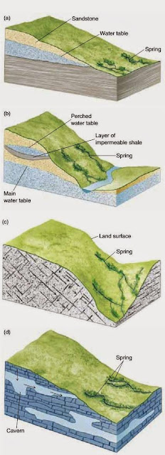
A spring occurs when ground water intersects the surface and water seeps through and flows on land. Above the water table in hill mostly the water is trapped by an impermeable layer and water flows from them, this is called perched aquifer.

Artesian wells

An inclined aquifer where its top and bottom is bounded by impermeable layer is an artesian aquifer. The underlying water is pressurized by the above water so when well is drilled the water comes out without being pumped this is called artesian well.

Ground water depletion

When water is pumped at high rate than of water inflow to the well, a cone of depletion appears. This cone can disappear if the pumped is turned of and water in a few weeks recharges the water table below well. If the water is pumped more rapidly or if there are many wells pumping from the same aquifer than the water table will drop down. By the new technologies, high efficiency pumps production where it can pump rapidly than that of the aquifer recharge, it will deplete. 

الأحد، 14 سبتمبر 2014

Geochemical Sampling

What is geochemical sampling?

Geochemical sampling is taking a small portion of Earth's material for finding its mineralogy, composition and grade such that it represent the whole area. Geochemical sampling is the basic technique used for the exploration of  minerals and their ores. So for this exploration multiple sampling techniques can be used to determine the place of ores. There are several methods of sampling


  • Stream sampling
  • Vegetation sampling
  • Hydrogeochemistry
  • Soil sampling
  • Gas sampling
  • Rock sampling

Stream sampling

Stream sampling is the samples taken from stream running through area and providing water and sediments from catchment area. These water when flow in stream it provides picture of the area from where water flows out. The stream source of sediments are by erosion of soil and rocks. It also gets water from inflow ground water which gives the subsurface mineralogy. So taking samples from the stream requires choosing area which provides picture of whole stream, sediments should be 80 mesh size acquired by sieving. Gold, magnetite concentrates in the stream sediments will settle down on the sieves as they are heavy minerals and finer sediments will be sieved. 
For base metals and geochemical mapping 0.5 kg sample should be taken but for Gold 10 kg sample should be analysed. For an active stream sampling should be at interval of 20-30 meters or 50-100 meters. Sampling should be from a depth of 10-15 centimetres to avoid excessive Iron and Manganese oxides. Panning should be done for Gold, Zinc, Garnet, Magnetite and Diamond.

Vegetation sampling

Vegetation sampling should be done where soil and ground water chemistry knowledge is required. It is useful in areas where soil samples are not available.

Geobotanical survey

Geobotanical survey is looking for a specific specie presence or absence that can indicate mineralization or specific rocks type. Certain plants especially flowering plants act as a exploratory guides or indicator to certain elements. Other cases are discoloration or stunted growth of plants. Example Mauve Cu flower or Beccium Humblei of Zambian Cu belt requires 50-1600 ppm (parts per million) to thrive.

Biogeochemistry

Biogeochemistry is the most used sampling technique in countries like Siberia and Canada where soil sampling is not easy so plant sampling is acquired to understand the subsurface geochemistry. Plants need most trace elements which are transmitted from ground through roots. Sampling is done through one plant specie where its first or second year leaves and twigs and samples. Sample 0.5 kg is then burned to ash which will be analysed through XRF, XRD and AAS.

Hydrogeochemistry

Water is used as medium of sampling because ores and minerals have effect on composition of water through dissolution. This technique have restriction as not all elements have equal dissolution rates, Some are insoluble, trace element concentration is very low to detect, Concentration is highly depending on climate and weathering, easily contaminated and ineffective in dry conditions.
However it is useful in areas where network of interconnected streams are present. Effective for fluorine and associated minerals, dissolved uranium and radon can help for uranium ores exploration and areas where sediments are not available. Lakes and bogs water are analysed for underlying mineralizations.

Soil sampling

Soil are of two types and accordingly can be used.
  • Residual soil
  • Exotic soil

Residual soil

Residual soil are those which are derived from the underlying rocks and gives clear picture of the subsurface. It is effected in areas where rock outcrop is not available so for this purpose selection of horizon is important. Soil horizons are OABC where B horizon is sampled because it is zone of accumulation and provides overall soil mineralogy. Where B horizon is not present so any horizon can be samples or all of the soil can be samples. Usually 100-200 grams is samples for lead, zinc, copper and 0.5-2 kg for gold.

Exotic soil

Exotic soil are those which is derived from other places so these can be used in glacial environments and is sandy desserts where finer particles are blown away so coarser are sampled for geochemical surveys.

Gas sampling

Gas sample are used as they can diffuse through over burden. A number of gases are used in finding different ores. Mercury is used for mercury deposits, uranium deposits and sulphide deposits. Radon and helium and gases used as an indicator for uranium deposits. Sulphide di oxide is used for oxidising sulphide mineralization. 

Rock sampling

Rock sampling is the most reliable and flexible method where large outcrops are available because rocks cannot be contaminated easily. Rock samples can be directly used for rock types, structure, mineralization and alteration. Rock sample can be stored for later examination and testing. Limitation in rock sampling are: outcrop not always available, scope is narrow and it shows only specific site not entire area. 0.5-1 kg samples is used for base metals and 10 kg sample for gold. Rock sample testing can only be done in laboratory and it consumes time.

Depositional Environments


There are many environments and every one has it's own characteristics. Every single depositional system have many environments where sediments deposits. On a broader sense there are three main types of depositional environments.
  1. Continental
  2. Terrestial
  3. Marine

Continental

Continental of-course the name simplifies it in understanding, it is the all environments on the continent. Continental environments include 
  • Glacial 
  • Lacustrine
  • Fluvial
  • Dessert

Glacial

Glacial environments are those related to snow and ice. When it snows on the continent or mountain ranges after certain time snow becomes more rigid and become ice. The ice melting water carry sediments with itself and these deposits are then glacial deposits. Snow and ice creeps along the slopes where it carries sediments and boulders along itself and deposits where it velocity decreases. As ice can carry sediments to boulders therefore it's deposits are not sorted (fining upward), it's deposit can be distinguished by unsorting called tillites. 

Lacustrine

Lacustrine are the deposition in lakes. The sediments coarser to finer according to the streams power to carry sediments are deposited in the lakes. As to the gravity action the coarser sediments deposits first and then the finer particles therefore it gives a fining upward succession. Coarser are at the base and fine upward.

Fluvial

Fluvial deposits are the water channels deposition. These can be in the streams and rivers. Water manages to carry load from boulder to fine sediments according to the velocity of the water. Boulders are usually carried to a certain distance in a mountain ranges sometimes during flooding the capacity increases where water possess huge velocity. Water dumps it's load where the velocity breaks  As velocity decrease will first deposit coarser sediment and then finer, it also have fining upward succession.

Dessert 

Desert are the places where average rainfall is less than 25mm/year. So any deposition in such areas are considered as dessert deposits. In dessert mostly deposition is aeolian (wind). Wind takes finer sediments with itself and deposits elsewhere when wind speed breaks. The sediments are rounded as the corners are round by friction.

Terrestial 

These are environments that are present in the junction of marine and continent. These includes
  • Delta
  • Lagoon
  • Beach

Delta

Delta deposits are those of the rivers mouth. Rivers carry continental sediments and are deposited where rivers open into sea/ocean. The coarser sediments are deposited at the early opening of river mouth where water velocity breaks and finer sediments are carried along water to the sea/ocean. Water channels are present like birds feet as water moves along different direction. 

Lagoon

Lagoon environments are those when sea/ocean water moves landward and it separates from main water body. These separated water makes environment where sediments deposits on continent.

Beach

Beach deposits are the terrestial environments on the onshore. Here deposits are mainly sand particles and some finer sediments are also present.

Marine

Marine environment as name indicates it is the deposition in the sea/ocean, open water body. These includes
  • Continental shelf
  • Continental slope
  • Open marine

Continental shelf

Continental shelf is the shallow marine environment where landmass from continent is submerged by ocean water. These environments comes in marine as landmass in submerged by water. Continental shelf has major deposits of sand, clay  and corals. Coral reefs live in colonial form and are mostly on the continental shelf, shallow marine environment.

Continental slope

Continental slope is environment where continental landmass slopes into sea/ocean. Deposition on this slope are referred as continental slope deposits which are finer sediments. These sediments can be reworked by turbiditic currents to open marine environments. 

Open marine

Open marine environment is the overall ocean deposits where it starts after continental slope. This environment deposits are from finer to coarser, organism remains, basalts etc in deposit. All animal living in free water are deposited in open marine along with sediments (Continental and terrestial). These sediments supply are deposited in ocean.

السبت، 13 سبتمبر 2014

Igneous rocks

Igneous rocks are those formed by the direct cooling of magma or lava.
Magma or lava is the molten form of rocks where intense heat turns them into hot magma. This is semi fluid and is in the subsurface. This magma can come out and produce lava and this also intrude in the joints or into the parent rock which is called dykes or sills. Igneous rocks are of two types according to the place where they forms i.e. intrusive and extrusive.

Intrusive

Intrusive rocks are those which are formed in the subsurface by direct cooling of the magma with overburden pressure. These rocks cools down gradually thereby giving time for minerals forming larger crystals. These are also called plutonic rocks. Intrusive rocks possess greater hardness than that of the volcanic rocks, this is because of the gradual cooling example are Granite, Gabbro and Peridotite. 

Extrusive

Extrusive or volcanic rocks are formed by the lava when it erupts from the subsurface. As in the open air and release of overburden pressure they cools rapidly and produces smaller crystals. The examples of volcanic rocks are Rhyolite, volcanic glass and many more.

Metamorphic rocks

Metamorphic rocks are formed by the heating of pre-existing rocks. The heat provide to a rock changes it mineralogical and physical changes which are called metamorphic rocks.

These rocks forms mostly where magma chamber is available to heat enough for mineralogical changes occurrence. These rocks have multiple features in distinguishing like schistosic, gneissic and slaty texures.


Texture is the physical character or a pattern.

Slaty texture

Slate are formed by the metamorphism of shale. Sheets are formed in the slates where it can broke  into sheets. This help in determining the slates.

Schistose

Schistose is formed after metamorphism of slate where it rearrange in forming irregular sheets like character which is schistosic texture.

Gneissic

Gneiss is the high grade metamorphic rock of shale which is distinguished by regular interval of dark and light bands present in it. These are called gneissic bands which is the recognizable character.

Metamorphism and its changes are following

Shale- Slate- Schist - Gneiss
Shale is sedimentary rock when metamorphose produces slate and slate to schist and schist to gneiss with increasing metamorphic grades. In the same way marble is produced by the metamorphism of limestone.

الجمعة، 12 سبتمبر 2014

Sedimentary rocks

Sedimentary rocks

Sedimentary rocks are those which are made up of pre-existing small particles called sediments. There are two types of sedimentary rocks
  • clastic
  • non clastic

Clastic 

Clastic rocks are those which are made up of sediments that are transported from other places. The sediment supply to the deposition are can be by the help of wind, gravity, water or ice. These rocks have many examples including sandstone and shale. The sandstone are made up of grains clustered together by the means of cements. Cement is the mineral that hold rock together, not splitting them in finer grains. Cement in the sandstone are silica or calcite. The sand particles are carried to the depositional area with the help of wind, an example of desert or the rivers deposits with the help of water. The grains are suspended either in the water or wind and when both medium speed breaks it can not carry the weight so are then deposited. It takes million years in order to the deposited sediments to form a rock as it needs pressure which can be overburden. It forms a rock which is called clastic rock.

Non clastic

Non clastic rocks are those which deposits at the area of origin. These sediments are not reworked by trasporting agents but are thus deposited where it have been formed or at lesser distance travel. These are also formed by the weathering process but not the erosional process. The best example of non clastic rocks are coral reefs. Corals habitat is colonial so when they die, deposits at its origin place. Limestone can also be formed clastically when the shells are reworked by turbiditic currents and drops calcium carbonate shells from shallow marine to deeper portion but eventually that won't be non clastic.

Weathering

Weathering

Weathering is the dissemination, destruction or breaking of the rock to finer particles. Weathering occur by many means, it can be either chemical, organic or mechanical.

Chemical weatheing

Chemical weathering occurs by the ion exchange method, dissolution of some particles which breaks the bond and the rock is thus weathered. The rock is dissolved when it is acid rain and the rock weathers. the best example in understanding chemical weathering is water dissolving limestone producing Karst topography. This help in the building of sedimentary rocks by erosion. Erosional means are wind, gravity, ice and water. When sediments are eroded it deposits at some other place, builds sedimentary rocks

Organic weathering

Organic as the name indicates is done by organisms. Plant roots break rock when they move into the rock and so the weathering process occurs.Rock is first weakened by penetrating forces of roots and thus split into smaller and smaller pieces. These are then eroded.

Mechanical weathering

Mechanical weathering is the physical breaking of a rock by means of force. The best example of the mechanical weathering is the permafrost. The water enters the pores and joints of a rock and when it freezes at low temperature areas. As the property of water at freezing is expansion so the water in rocks expands which widens the spaces and after some time disintegrated.

The deposition of these sediments occur when wind, water or ice slows in speed and have no capacity to blow away the particles, it deposits.

الخميس، 11 سبتمبر 2014

Types of rocks

There are three main types of rocks
Sedimentary
Metamorphic
Igneous

Sedimentary rocks

Sedimentary rocks are those that are produced by the deposition of sediments (small particles). The sediments cluster and are cemented that produces a rock. Sedimentary rocks are also called soft rocks as they are not produced by heat factor but are produced by the weathering of the rocks that are exposed on the Earth surface. 

Metamorphic rocks

Metamorphic rocks are those which minerals are changed by heat not directly magma but heat which does not melt it but only changes the mineralization. 

Igneous rocks

Igneous rocks are those which are produced by the direct melting rocks (magma). The magma cooling in the subsurface are called plutonic or intrusive rocks and those lava cooling on the surface are the volcanic or extrusive rocks.

The rock cycle changes the rocks from one form into another.

Kerogen types

Petroleum

Petroleum is basically the  fossil fuel. Hydrocarbon C and H are the components that make up different types of fuel example oil, gas and coal. Well the generation of hydrocarbon type is given by a specific type of Kerogen. 

Kerogen

Kerogen is the organic matter that are deposited, it can be made up of different types. Example micro-organism, sea plants, land plants etc.
Different type of Kerogen produces different type of hydrocarbon

Type I Kerogen

This type of Kerogen comprises organic matter of microorganisms which is mostly from sea, they settle down at the bottom of the sea when they die and deposit. These type gives mostly oil and less gas.

Type II Kerogen

This comprises mostly of the sea plants and less animal so they care to generate oil and gas but mostly gas and less oil.

Type III Kerogen

This has the terrestial (land) plants and as you know coal is formed by the remains of plants so type 3 gives coal and less oil and gas comparative higher proportion.

Type IV Kerogen

This type of kerogen is oxidized and in order for the hydrocarbon generation the organic matter should not be oxidized or they will not produce the fuel. So the type 4 give inert gases as organic matter is oxidized and produce less gas, not economical.

الأربعاء، 10 سبتمبر 2014

Structure Geology

Structure Geology

Structure Geology as the name indicates it is related to structures. What kind of structures are to be observed in this field?.
The basic structures that is often used are
  • Faults 
  • Folds 

Faults

Faults are defined as the displacement or the movement in the rocks that make up the Earth's crust.
Figure 1. Fault in the Earth's crust.
As shown in the figure 1 the arrows indicate the movement of the rocks, the movement is referred as comparative movement. there are different types of fault's as further divided by the way of displacement.
The block that moves relative to another is the hanging-wall and the block which is static at it's position is the foot wall. The foot wall can Move upward and downward. So the fault as divided are by this movement.
When hanging-wall moves downward with respect to action of gravity of the above burden it is called normal fault. And the hanging wall upward movement is called reverse fault as is against the gravity.
The major division of the faults are strike-slip and dip-slip
Strike slip faults are along strike so in order to understand the strike slip 1st strike should be known.
Strike is the line which is at right angle to the dip direction. Strike is formed by the intersection of dip direction and imaginary line that run along the horizontal surface.
Figure 2. Strike and dip directions are shown.
So strike slip faults are called transform faults their movement is along strike and pass one another.
Figure 3. On the lower left is reverse fault and to the right is strike slip or transform fault.
Dip-slip faults includes normal and reverse fault. Once again had to acknowledge that normal faults are those which moves according to the gravity action and reverse faults are those which moves anti-gravity. These faults are the reason for the earthquakes. When movement of the two Earth crust block trigger it rubs against each other and as their are solid rocks, they are rough and keeps the crust intact so their movement triggers earthquake.

Folds

Folds are the structures that are formed due to plate movements. Faults are also responsible in its forming. These are the folded starta of the Earth's crust the fold are formed when originally horizontal strata as deposition is always horizontal it is curved or bent, deformation in the strata due to forces.
Figure 4. Component of fold.
Fold are basically the deformation and it occurs when forces on both sides, somewhere the forces have to be accommodated so the strata where it can bend, forms the fold. There are types of folds anticline and syncline.
Anticline is shown in the figure 4 it is the convex upward fold. In it's inner part, lowest one will have the older rocks as it is the core and younger on the limbs and hinge. the syncline is the vice-versa. It will be concave upward and in the core the inner portion will have the younger rocks the limbs will have older rocks.

What is Geology?

What is geology?

Geology is the study of the Earth, the materials of which it is made, the structure of those materials, and the processes acting upon them. It includes the study of organisms that have inhabited our planet. An important part of geology is the study of how Earth's materials, structures, processes and organisms have changed over time.


What Does a Geologist Do?

Geologists work to comprehend the historical backdrop of our planet. The better they can comprehend Earth's history, the better they can predict how occasions and procedures of the past might impact what's to come. Here are a few illustrations:
Volcanic Hazards Map: Geologists prepared this volcanic hazards map to communicate the location of hazardous areas to citizens, government agencies, and businesses. To prepare a map like this requires an understanding of volcanoes, an ability to recognise volcanic deposits in the field, an ability to prepare a map, and an ability to communicate. All geological tasks require a diversity of skills. This is why students who are interested in geology are encouraged to do well in all of their courses and to seek advanced training in Earth science, chemistry, physics, math, computers, and communication skills.

Geologists study Earth processes

Many procedures, for example, avalanches, tremors, surges, and volcanic emissions can be perilous to individuals. Geologists work to comprehend these procedures all around well enough to abstain from building essential structures where they may be harmed. On the off chance that geologists can plan maps of territories that have overflowed before, they can get ready maps of ranges that may be overwhelmed later on. These maps can be utilised to direct the improvement of groups and figure out where surge assurance or surge protection is required.

Geologists study Earth materials

Individuals utilise Earth materials consistently. They utilise oil that is created from wells, metals that are delivered from mines, and water that has been drawn from streams or from underground. Geologists lead concentrates that find shakes that contain imperative metals, arrange the mines that deliver them and the techniques used to expel the metals from the stones. They do comparable work to find and deliver oil, common gas, and groundwater.

Geologists study Earth history

Today we are worried about environmental change. Numerous geologists are attempting to find out about the past atmospheres of Earth and how they have changed crosswise over time. This authentic geography news data is important to see how our present atmosphere is changing and what the outcomes may be.


Geology as a Career

Geology can be an extremely intriguing and remunerating vocation. The base preparing required is a four-year higher education in geography. Pre-understudies who are keen on getting to be geologists ought to take a full educational programs of school preliminary courses, particularly those in math, science, and composing. Courses identified with PCs, topography and correspondence are likewise significant. 
Geologists work in an assortment of settings. These include: normal asset organisations, natural counselling organisations, government offices, non-benefit associations, and colleges. Numerous geologists do handle work at any rate part of the time. Others invest their energy in research facilities, classrooms or workplaces. All geologists plan reports, do computations and utilise PCs. 
In spite of the fact that a four year certification is required for passage level business, numerous geologists procure ace's and additionally doctorate degrees. The propelled degrees give a more elevated amount of preparing, regularly in a geography claim to fame territory, for example, fossil science, mineralogy, hydrology, or volcanology. Propelled degrees will frequently qualify the geologist for supervisory positions, inquire about assignments, or showing positions at the college level. These are probably the most looked for after employments in the field of geography. 
Work open doors for geologists are great. Most topography graduates with a solid scholarly foundation and decent evaluations experience no difficulty discovering business on the off chance that they will move to an area where work is accessible.

Employment Outlook

Throughout the following quite a long while, the quantity of geography employment opportunities is relied upon to surpass the quantity of understudies moving on from college topography programs. Beginning pay rates for geologists have as of late extended from $50,000 to $100,000 every year.

How Can You Become a Geologist?

On the off chance that you are a pre-undergrad, you can get ready to wind up distinctly a geologist by doing admirably in the greater part of your courses. Science courses are particularly essential, however math, composition, and different controls are utilised by each geologist amid each working day. 
In the event that you are thinking about school or doctoral level college, there are numerous colleges that offer courses or projects in geography. Visit the site of a school that offers a topography degree, connect with the geography office, let them know you are intrigued and make game plans to visit the grounds. Try not to be reluctant. Great schools and teachers need to be reached by intrigued understudies.

الخميس، 4 سبتمبر 2014

Underground Drilling and Blasting

Underground Drilling and Blasting


super pit blast kalgoorlie


super pit blast kalgoorlie


super pit blast kalgoorlie

Interested for our works and services?
Get more of our update !